[:en]Takht-e Soleyman[:de]Takht-e Suleyman[:fr]Takht-e Soleyman[:]
[:en]
Takht-e Soleyman
The archaeological site of Takht-e Soleyman, in north-western Iran, is situated in a valley set in a volcanic mountain region. The site includes the principal Zoroastrian sanctuary partly rebuilt in the Ilkhanid (Mongol) period (13th century) as well as a temple of the Sasanian period (6th and 7th centuries) dedicated to Anahita. The site has important symbolic significance. The designs of the fire temple, the palace and the general layout have strongly influenced the development of Islamic architecture.
Brief Synthesis
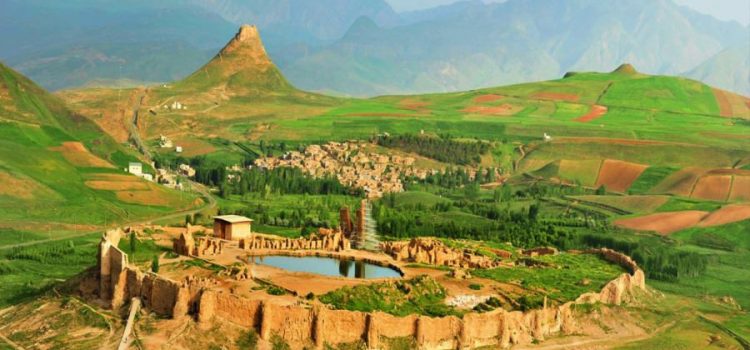
The archaeological ensemble called Takht-e Soleyman (“Throne of Solomon”) is situated on a remote plain surrounded by mountains in northwestern Iran’s West Azerbaijan province. The site has strong symbolic and spiritual significance related to fire and water – the principal reason for its occupation from ancient times – and stands as an exceptional testimony of the continuation of a cult related to fire and water over a period of some 2,500 years. Located here, in a harmonious composition inspired by its natural setting, are the remains of an exceptional ensemble of royal architecture of Persia’s Sasanian dynasty (3rd to 7th centuries). Integrated with the palatial architecture is an outstanding example of Zoroastrian sanctuary; this composition at Takht-e Soleyman can be considered an important prototype.
An artesian lake and a volcano are essential elements of Takht-e Soleyman. At the site’s heart is a fortified oval platform rising about 60 metres above the surrounding plain and measuring about 350 m by 550 m. On this platform are an artesian lake, a Zoroastrian fire temple, a temple dedicated to Anahita (the divinity of the waters), and a Sasanian royal sanctuary. This site was destroyed at the end of the Sasanian era, but was revived and partly rebuilt in the 13th century. About three kilometres west is an ancient volcano, Zendan-e Soleyman, which rises about 100 m above its surroundings. At its summit are the remains of shrines and temples dating from the first millennium BC.
Takht-e Soleyman was the principal sanctuary and foremost site of Zoroastrianism, the Sasanian state religion. This early monotheistic faith has had an important influence on Islam and Christianity; likewise, the designs of the fire temple and the royal palace, and the site’s general layout, had a strong influence on the development of religious architecture in the Islamic period, and became a major architectural reference for other cultures in both the East and the West. The site also has many important symbolic relationships, being associated with beliefs much older than Zoroastrianism as well as with significant biblical figures and legends.
The 10-ha property also includes Tepe Majid, an archaeological mound culturally related to Zendan-e Soleyman; the mountain to the east of Takht-e Soleyman that served as quarry for the site; and Belqeis Mountain 7.5 km to the northeast, on which are the remains of a Sasanian-era citadel. The archaeological heritage of the Takht-e Soleyman ensemble is further enriched by the Sasanian town (which has not yet been excavated) located in the 7,438-ha landscape buffer zones.
Criterion (i):Takht-e Soleyman is an outstanding ensemble of royal architecture, joining the principal architectural elements created by the Sasanians in a harmonious composition inspired by their natural context.
Criterion (ii):The composition and the architectural elements created by the Sasanians at Takht-e Soleyman have had strong influence not only in the development of religious architecture in the Islamic period, but also in other cultures.
Criterion (iii):The ensemble of Takht-e Soleyman is an exceptional testimony of the continuation of cult related to fire and water over a period of some two and half millennia. The archaeological heritage of the site is further enriched by the Sasanian town, which is still to be excavated.
Criterion (iv):Takht-e Soleyman represents an outstanding example of Zoroastrian sanctuary, integrated with Sasanian palatial architecture within a composition, which can be seen as a prototype.
Criterion (vi): As the principal Zoroastrian sanctuary, Takht-e Soleyman is the foremost site associated with one of the early monotheistic religions of the world. The site has many important symbolic relationships, being also a testimony of the association of the ancient beliefs, much earlier than the Zoroastrianism, as well as in its association with significant biblical figures and legends.
Integrity
Within the boundaries of the property are located the known elements and components necessary to express the Outstanding Universal Value of the property, including the lake and the volcano, archaeological remains related to the Zoroastrian sanctuary, and archaeological remains related to the royal architecture of the Sasanian dynasty. Masonry rooftops have collapsed in some areas, but the configurations and functions of the buildings remain evident.
The region’s climate, particularly the long rainy season and extreme temperature variations, as well as seismic action represent the major threats to the integrity of the original stone and masonry materials. Potential risks in the future include development pressures and the construction of visitor facilities in the buffer zones around the sites. Furthermore, there is potential conflict between the interests of the farmers and archaeologists, particularly in the event that excavations are undertaken in the valley fields.
Authenticity
The Takht-e Soleyman archaeological ensemble is authentic in terms of its forms and design, materials and substance, and location and setting, as well as, to a degree, the use and the spirit of the fire temple. Excavated only recently, the archaeological property’s restorations and reconstructions are relatively limited so far: a section of the outer wall near the southern entrance has been rebuilt, using for the most part original stones recovered from the fallen remains; and part of the brick vaults of the palace structures have been rebuilt using modern brick but in the same pattern as the original. As a whole, these interventions can be seen as necessary, and do not compromise the authenticity of the property, which retains its historic ruin aspect. The ancient fire temple still serves pilgrims performing Zoroastrian ceremonies.
Protection and management requirements
Takht-e Soleyman was inscribed on the national heritage list of Iran in 1931, and it is subject to legal protection under the Law on the Protection of National Treasures (1930, updated 1998) and the Law of the Iranian Cultural Heritage Organization Charter (n. 3487-Qaf, 1988). The inscribed World Heritage property, which is owned by the Government of Iran, is under the legal protection and management of the Iranian Cultural Heritage, Handicrafts and Tourism Organization (which is administered and funded by the Government of Iran). Acting on its behalf, Takht-e Soleyman World Heritage Base is responsible for implementation of the archaeology, conservation, tourism, and education programmes, and for site management. These activities are funded by the Iranian Cultural Heritage, Handicrafts and Tourism Organization, as well as by occasional international support. The current management plan, prepared in 2010, organises managerial strategies and activities over a 15-year period.
Sustaining the Outstanding Universal Value of the property over time will require continuing periodic on-site observations to determine whether the climate or other factors will lead to a negative impact on the Outstanding Universal Value, integrity or authenticity of the property; and employing internationally recognised scientific standards and techniques to properly safeguard the monuments when undertaking stabilisation, conservation, or restoration projects intended to address such negative impacts.
[:de]Die archäologische Stätte Takht-e Suleyman im Nordwesten des Iran liegt in einer vulkanischen Bergregion. Das Gelände umfasst das wichtigste zarathustrische Heiligtum, das teilweise in der Ilkhanidenzeit (13. Jahrhundert) wiederaufgebaut wurde, sowie einen Tempel der Sassanidenzeit (6. und 7. Jahrhundert), der Anahita gewidmet ist. Die Anlage hat eine wichtige symbolische Bedeutung.
Die Entwürfe des Feuertempels, des Palastes und des allgemeinen Grundrisses haben die Entwicklung der islamischen Architektur stark beeinflusst.
Kurze zusammenzetzung
Die archäologische Stätte Takht-e Suleyman im Nordwesten des Iran liegt in einer vulkanischen Bergregion. Das Gelände umfasst das wichtigste zarathustrische Heiligtum, das teilweise in der Ilkhanidenzeit (13. Jahrhundert) wiederaufgebaut wurde, sowie einen Tempel der Sassanidenzeit (6. und 7. Jahrhundert), der Anahita gewidmet ist. Das Gelände hat eine wichtige symbolische Bedeutung. Die Entwürfe des Feuertempels, des Palastes und des allgemeinen Grundrisses haben die Entwicklung der islamischen Architektur stark beeinflusst.
Ein artesischer See und ein Vulkan sind wesentliche Elemente von Takht-e Suleyman. Im Zentrum des Standortes befindet sich eine befestigte ovale Plattform, die sich etwa 60 Meter über der umliegenden Ebene erhebt und etwa 350 Meter mal 550 Meter misst. Auf dieser Plattform befinden sich ein artesischer See, ein zarathustrischer Feuertempel, ein Tempel, der Anahita (der Göttlichkeit der Gewässer) gewidmet ist, und ein sassanianisches königliches Heiligtum. Dieser Ort wurde am Ende der Sassanidenzeit zerstört, aber im 13. Jahrhundert teilweise wieder aufgebaut und wiederbelebt. Ungefähr drei Kilometer westlich von dem Gelände befindet sich ein alter Vulkan. Zendan-e Suleyman erhebt sich etwa 100 m über seiner Umgebung. Auf seinem Gipfel befinden sich die Überreste von Schreinen und Tempeln aus dem ersten Jahrtausend vor Christus.
Kriterium (i): Takht-e Suleyman ist ein herausragendes Ensemble königlicher Architektur, das die wichtigsten architektonischen Elemente der Sassaniden in einer harmonischen Komposition vereint,und von ihrem natürlichen Kontext inspiriert ist.
Kriterium (ii): Die Zusammensetzung und die architektonischen Elemente, die von den Sassanians in Takht-e Suleyman geschaffen wurden, haben nicht nur die Entwicklung der religiösen Architektur in der islamischen Periode, sondern auch andere Kulturen stark beeinflusst.
Kriterium (iii): Das Ensemble von Takht-e Suleyman ist ein außergewöhnliches Zeugnis der Fortdauer des Kultes in Bezug auf Feuer und Wasser in einem Zeitraum von etwa zweieinhalb Jahrtausenden. Das archäologische Erbe des Ortes wird durch die Sassan Stadt, die noch ausgegraben werden muss, noch bereichert.
Kriterium (iv): Takht-e Suleyman stellt ein herausragendes Beispiel des zarathustrischen Heiligtums dar, das in die sassanidische palastartige Architektur in einer Komposition integriert wurde, und als Prototyp angesehen werden kann.
Kriterium (vi): Als wichtigstes zarathustrisches Heiligtum ist Takht-e Soleyman der wichtigste Ort, der mit einer der frühen monotheistischen Religionen der Welt verbunden ist. Der Ort hat viele wichtige symbolische Beziehungen, er ist auch ein Zeugnis der Verbindung der alten Glaubensvorstellungen, viel früher als der Zarathus Integrität
Innerhalb der Grenzen der Anlage befinden sich die bekannten Elemente und Komponenten, die notwendig sind, um den außergewöhnlichen universellen Wert des Grundstücks auszudrücken, einschließlich des Sees und des Vulkans, archäologische Überreste des zarathustrischen Heiligtums und archäologischen königlichen Architektur des Sassaniden Dynastie. Die Dächer von Gemäuern sind in einigen Bereichen eingestürzt, aber die Konfigurationen und Funktionen der Gebäude bleiben offen. Das Klima der Region, insbesondere die lange Regenzeit und die extremen Temperaturschwankungen, sowie Einwirkungen von Erschütterungen sind die größten Bedrohungen für die Integrität der ursprünglichen Materialien aus Stein und Mauerwerk. Zu den möglichen Risiken in der Zukunft gehören Entwicklungsdruck und der Bau von Besuchereinrichtungen in den Pufferzonen um die Standorte herum. Darüber hinaus besteht ein potenzieller Konflikt zwischen den Interessen der Landwirte und Archäologen, insbesondere wenn Ausgrabungen in den Talfeldern vorgenommen werden.
Authentizität
Das archäologische Ensemble Takht-e Suleyman ist authentisch in Bezug auf Formen und Design, Materialien und Substanz, Lage und Umgebung sowie in gewissem Maße auf den Gebrauch und den Geist des Feuertempels. Die erst kürzlich ausgegrabenen Restaurierungen und Rekonstruktionen der archäologischen Anlage sind bisher relativ begrenzt. Ein Teil der äußeren Mauer in der Nähe des südlichen Eingangstors wurde wieder aufgebaut, wobei größtenteils Originalsteine aus den gefallenen Überresten verwendet wurden. Ein Teil der Backsteingewölbe der Palastbauten wurde mit modernen Ziegeln im gleichen Muster wie das Original wieder aufgebaut. Insgesamt können diese Eingriffe als notwendig angesehen werden und beeinträchtigen nicht die Echtheit der Immobilie, die ihren historischen Ruinaspekt beibehält. Der antike Feuertempel dient immer noch Pilgern, die zarathustrische Zeremonien durchführen.
Schutz- und Managementanforderungen
Takht-e Suleyman wurde 1931 in die Liste des nationalen Erbes des Iran eingetragen und unterliegt dem gesetzlichen Schutz der nationalen Schätze (1930, aktualisiert 1998) und des Gesetzes der iranischen Kulturerbe-Organisation (n 3487-Qaf, 1988). Das denkmalgeschützte Weltkulturerbe, das Eigentum der iranischen Regierung ist, steht unter dem rechtlichen Schutz und der Verwaltung der iranischen Organisation für Kulturerbe, Handwerk und Tourismus (die von der iranischen Regierung verwaltet und finanziert wird). In ihrem Auftrag ist Takht-e Suleyman Weltkulturerbe,wo sie für die Umsetzung der Programme für Archäologie, Naturschutz, Tourismus und Bildung sowie für das Management von Baustellen verantwortlich sind. Diese Aktivitäten werden vom iranischen Kulturerbe, der Handwerks- und Tourismusorganisation sowie gelegentlich international finanziell unterstützt. Der aktuelle Managementplan, der 2010 erstellt wurde, organisiert Managementstrategien und -aktivitäten über einen Zeitraum von 15 Jahren.
Um den außergewöhnlichen universellen Wert der Immobilie im Laufe der Zeit aufrecht zu erhalten, müssen regelmäßige Beobachtungen vor Ort durchgeführt werden, um festzustellen, ob das Klima oder andere Faktoren negative Auswirkungen auf den außergewöhnlichen universellen Wert, die Integrität oder die Echtheit der Immobilie haben.Um die Denkmäler bei der Durchführung von Stabilisierungs-, Konservierungs- oder Restaurierungsprojekten angemessen zu schützen,werden international anerkannter wissenschaftlicher, Standards und Techniken angewandt.[:fr][vc_row][vc_column][vc_column_text]
Takht-e Soleyman
Le site archéologique de Takht-e Soleyman, dans le nord-ouest de l’Iran, est situé dans une vallée située dans une région montagneuse volcanique. Le site comprend le principal sanctuaire zoroastrien reconstruit en partie pendant la période Ilkhanide (XIIIe siècle) ainsi qu’un temple de la période sassanide (VIe et VIIe siècles) dédié à Anahita. Le site a une signification symbolique importante. Les dessins du temple du feu, du palais et de la configuration générale ont fortement influencé le développement de l’architecture islamique.
Brève synthèse
L’ensemble archéologique appelé Takht-e Soleyman («trône de Salomon») est situé dans une plaine isolée entourée de montagnes dans la province d’Azerbaïdjan occidental, au nord-ouest de l’Iran. Le site a une forte signification symbolique et spirituelle liée au feu et à l’eau – principale raison de son occupation depuis l’antiquité – et constitue un témoignage exceptionnel de la continuation d’un culte lié au feu et à l’eau pendant une période d’environ 2 500 ans. Ici, dans une composition harmonieuse inspirée par son cadre naturel, se trouvent les vestiges d’un ensemble exceptionnel d’architecture royale de la dynastie Sassanide de Perse (IIIe-VIIe siècles). Intégré à l’architecture du palais est un exemple exceptionnel de sanctuaire zoroastrien; cette composition chez Takht-e Soleyman peut être considérée comme un prototype important.
Un lac de la fontaine Artésien et un volcan sont des éléments essentiels de Takht-e Soleyman. Au cœur du site se trouve une plate-forme ovale fortifiée s’élevant à environ 60 mètres au-dessus de la plaine environnante et mesurant environ 350 m sur 550 m. Sur cette plate-forme se trouvent un lac artésien, un temple du feu zoroastrien, un temple dédié à Anahita (la divinité des eaux) et un sanctuaire royal sassanide. Ce site a été détruit à la fin de l’ère sassanide, mais a été relancé et partiellement reconstruit au XIIIe siècle. Environ trois kilomètres à l’ouest se trouve un ancien volcan, Zendan-e Soleyman(le prison de Soleyman), qui s’élève à environ 100 m au-dessus de ses environs. Au sommet se trouvent les vestiges de sanctuaires et de temples datant du premier millénaire avant notre ère.
Takht-e Soleyman était le principal sanctuaire pour le site du zoroastrisme, la religion d’État sassanide. Cette première religion monothéiste a eu un impact significatif sur l’islam et le christianisme; de même, les dessins du temple du feu et du palais royal, ainsi que l’aménagement général du site, ont fortement influencé l’évolution de l’architecture religieuse à l’époque islamique et sont devenus une référence architecturale majeure pour d’autres cultures, à l’est comme à l’ouest . Le site entretient également de nombreuses relations symboliques importantes, étant associé à des croyances bien plus anciennes que le zoroastrisme ainsi qu’à des personnages et légendes bibliques significatifs.
La propriété de 10 hectare comprend également Tepe Majid, un monticule archéologique lié culturellement à Zendan-e Soleyman; la montagne à l’est de Takht-e Soleyman et la montagne Belqeis, à 7,5 km au nord-est, vestiges d’une citadelle de l’époque sassanide. Le patrimoine archéologique de l’ensemble Takht-e Soleyman est encore enrichi par la ville sassanide (qui n’a pas encore été fouillée) située dans les zones paysagères de 7 438 hectares.
Critère (i): Takht-e Soleyman est un ensemble exceptionnel d’architecture royale joignant les principaux éléments architecturaux créés par les Sassanide dans une composition harmonieuse inspirée par leur contexte naturel.
Critère (ii): La composition et les éléments architecturaux créés par les Sasanide à Takht-e Soleyman ont eu une forte influence non seulement sur le développement de l’architecture religieuse de la période islamique, mais également sur celle des autres cultures.
Critère (iii): L’ensemble de Takht-e Soleyman est un témoignage exceptionnel de la continuation du culte lié au feu et à l’eau sur une période de quelque deux mille cinq cents ans. Le patrimoine archéologique du site est enrichi par la ville sassanide, qui reste à fouiller.
Critère (iv): Takht-e Soleyman représente un exemple exceptionnel de sanctuaire zoroastrien, intégré à une architecture de palais sassanide dans une composition, qui peut être considérée comme un prototype.
Critère (vi): En tant que principal sanctuaire zoroastrien, Takht-e Soleyman est le site le plus important associé à l’une des premières religions monothéistes du monde. Le site entretient de nombreuses relations symboliques importantes, témoignant également de l’association d’anciennes croyances, bien avant le zoroastrisme, ainsi que d’associations avec d’importantes figures et légendes bibliques.
Intégrité
Les éléments et composants connus permettant d’exprimer la valeur universelle exceptionnelle du bien, y compris le lac et le volcan, se trouvent dans les limites du bien, ainsi que des vestiges archéologiques liés au sanctuaire zoroastrien et des vestiges archéologiques liés à l’architecture royale de la dynastie sassanide. Les toits de maçonnerie se sont effondrés dans certaines zones, mais les configurations et les fonctions des bâtiments restent évidentes.
Le climat de la région, en particulier la longue saison des pluies et les variations extrêmes de température, ainsi que l’action sismique constituent les principales menaces pour l’intégrité des matériaux de pierre et de maçonnerie d’origine. Les risques potentiels à l’avenir comprennent les pressions liées au développement et la construction d’installations pour les visiteurs dans les zones tampons autour des sites. En outre, il existe un conflit potentiel entre les intérêts des agriculteurs et des archéologues, en particulier dans le cas où des fouilles sont entreprises dans les champs de la vallée.
Authenticité
L’ensemble archéologique de Takht-e Soleyman est authentique par ses formes et sa conception, ses matériaux et sa substance, son emplacement et son cadre, ainsi que, dans une certaine mesure, par l’usage et l’esprit du temple du feu. Récemment excavées, les restaurations et reconstructions du bien archéologique sont relativement limitées à ce jour: une partie du mur extérieur près de l’entrée sud a été reconstruite, en utilisant pour la plupart des pierres d’origine récupérées des restes tombés; et une partie des voûtes en brique des structures du palais ont été reconstruites à l’aide de briques modernes, mais selon le même schéma que l’original.Dans l’ensemble, ces interventions peuvent être considérées comme nécessaires et ne compromettent pas l’authenticité du bien, qui conserve son aspect de ruine historique. L’ancien temple du feu accueille encore des pèlerins lors de cérémonies zoroastriennes.
Exigences de protection et de gestion
Takht-e Soleyman a été inscrit sur la liste du patrimoine national de l’Iran en 1931 et il est soumis à la protection légale conférée par la loi sur la protection des trésors nationaux (1930, mise à jour en 1998) et la charte du droit iranien à la protection du patrimoine culturel (n 3487-Qaf, 1988). Le bien inscrit au patrimoine mondial, qui appartient au gouvernement iranien, est sous la protection juridique et la gestion de l’Organisation iranienne pour le patrimoine culturel, l’artisanat et le tourisme (qui est administrée et financée par le gouvernement iranien). Agissant en son nom, la base du patrimoine mondial de Takht-e Soleyman est responsable de la mise en œuvre des programmes d’archéologie, de conservation, de tourisme et d’éducation, ainsi que de la gestion du site. Ces activités sont financées par l’Organisation iranienne du patrimoine culturel, de l’artisanat et du tourisme, ainsi que par un appui international occasionnel. Le plan de gestion actuel, préparé en 2010, organise des stratégies et des activités de gestion sur une période de 15 ans.
Le maintien de la valeur universelle exceptionnelle du bien au fil du temps nécessitera des observations périodiques sur place afin de déterminer si le climat ou d’autres facteurs auront un impact négatif sur la valeur universelle exceptionnelle, l’intégrité ou l’authenticité du bien; et en appliquant des normes et techniques scientifiques reconnues sur le plan international pour protéger correctement les monuments lors de la réalisation de projets de stabilisation, de conservation ou de restauration destinés à remédier à ces impacts négatifs.
[/vc_column_text][/vc_column][/vc_row][:]
[:en]Meidan Emam, Esfahan[:de]Meidan Emam , Isfahan[:fr]Meidan Emam, Esfahan[:]
[:en]Built by Shah Abbas I the Great at the beginning of the 17th century, and bordered on all sides by monumental buildings linked by a series of two-storeyed arcades, the site is known for the Royal Mosque, the Mosque of Sheykh Lotfollah, the magnificent Portico of Qaysariyyeh and the 15th-century Timurid palace. They are an impressive testimony to the level of social and cultural life in Persia during the Safavid era.
Outstanding Universal Value
Brief Synthesis
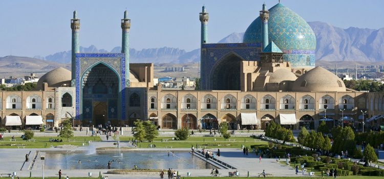
The Meidan Emam is a public urban square in the centre of Esfahan, a city located on the main north-south and east-west routes crossing central Iran. It is one of the largest city squares in the world and an outstanding example of Iranian and Islamic architecture. Built by the Safavid shah Abbas I in the early 17th century, the square is bordered by two-storey arcades and anchored on each side by four magnificent buildings: to the east, the Sheikh Lotfallah Mosque; to the west, the pavilion of Ali Qapu; to the north, the portico of Qeyssariyeh; and to the south, the celebrated Royal Mosque. A homogenous urban ensemble built according to a unique, coherent, and harmonious plan, the Meidan Emam was the heart of the Safavid capital and is an exceptional urban realisation.
Also known as Naghsh-e Jahan (“Image of the World”), and formerly as Meidan-e Shah, Meidan Emam is not typical of urban ensembles in Iran, where cities are usually tightly laid out without sizeable open spaces. Esfahan’s public square, by contrast, is immense: 560 m long by 160 m wide, it covers almost 9 ha. All of the architectural elements that delineate the square, including its arcades of shops, are aesthetically remarkable, adorned with a profusion of enamelled ceramic tiles and paintings.
Of particular interest is the Royal Mosque (Masjed-e Shah), located on the south side of the square and angled to face Mecca. It remains the most celebrated example of the colourful architecture which reached its high point in Iran under the Safavid dynasty (1501-1722; 1729-1736). The pavilion of Ali Qapu on the west side forms the monumental entrance to the palatial zone and to the royal gardens which extend behind it. Its apartments, high portal, and covered terrace (tâlâr) are renowned. The portico of Qeyssariyeh on the north side leads to the 2-km-long Esfahan Bazaar, and the Sheikh Lotfallah Mosque on the east side, built as a private mosque for the royal court, is today considered one of the masterpieces of Safavid architecture.
The Meidan Emam was at the heart of the Safavid capital’s culture, economy, religion, social power, government, and politics. Its vast sandy esplanade was used for celebrations, promenades, and public executions, for playing polo and for assembling troops. The arcades on all sides of the square housed hundreds of shops; above the portico to the large Qeyssariyeh bazaar a balcony accommodated musicians giving public concerts; the tâlâr of Ali Qapu was connected from behind to the throne room, where the shah occasionally received ambassadors. In short, the royal square of Esfahan was the preeminent monument of Persian socio-cultural life during the Safavid dynasty.
Criterion (i): The Meidan Emam constitutes a homogenous urban ensemble, built over a short time span according to a unique, coherent, and harmonious plan. All the monuments facing the square are aesthetically remarkable. Of particular interest is the Royal Mosque, which is connected to the south side of the square by means of an immense, deep entrance portal with angled corners and topped with a half-dome, covered on its interior with enamelled faience mosaics. This portal, framed by two minarets, is extended to the south by a formal gateway hall (iwan) that leads at an angle to the courtyard, thereby connecting the mosque, which in keeping with tradition is oriented northeast/southwest (towards Mecca), to the square’s ensemble, which is oriented north/south. The Royal Mosque of Esfahan remains the most famous example of the colourful architecture which reached its high point in Iran under the Safavid dynasty. The pavilion of Ali Qapu forms the monumental entrance to the palatial zone and to the royal gardens which extend behind it. Its apartments, completely decorated with paintings and largely open to the outside, are renowned. On the square is its high portal (48 metres) flanked by several storeys of rooms and surmounted by a terrace (tâlâr) shaded by a practical roof resting on 18 thin wooden columns. All of the architectural elements of the Meidan Imam, including the arcades, are adorned with a profusion of enamelled ceramic tiles and with paintings, where floral ornamentation is dominant – flowering trees, vases, bouquets, etc. – without prejudice to the figurative compositions in the style of Riza-i Abbasi, who was head of the school of painting at Esfahan during the reign of Shah Abbas and was celebrated both inside and outside Persia.
Criterion (v): The royal square of Esfahan is an exceptional urban realisation in Iran, where cities are usually tightly laid out without open spaces, except for the courtyards of the caravanserais (roadside inns). This is an example of aform of urban architecture that is inherently vulnerable.
Criterion (vi): The Meidan Imam was the heart of the Safavid capital. Its vast sandy esplanade was used for promenades, for assembling troops, for playing polo, for celebrations, and for public executions. The arcades on all sides housed shops; above the portico to the large Qeyssariyeh bazaar a balcony accommodated musicians giving public concerts; the tâlâr of Ali Qapu was connected from behind to the throne room, where the shah occasionally received ambassadors. In short, the royal square of Esfahan was the preeminent monument of Persian socio-cultural life during the Safavid dynasty (1501-1722; 1729-1736).
Integrity
Within the boundaries of the property are located all the elements and components necessary to express the Outstanding Universal Value of the property, including, among others, the public urban square and the two-storey arcades that delineate it, the Sheikh Lotfallah Mosque, the pavilion of Ali Qapu, the portico of Qeyssariyeh, and the Royal Mosque.
Threats to the integrity of the property include economic development, which is giving rise to pressures to allow the construction of multi-storey commercial and parking buildings in the historic centre within the buffer zone; road widening schemes, which threaten the boundaries of the property; the increasing number of tourists; and fire.
Authenticity
The historical monuments at Meidan Emam, Esfahan, are authentic in terms of their forms and design, materials and substance, locations and setting, and spirit. The surface of the public urban square, once covered with sand, is now paved with stone. A pond was placed at the centre of the square, lawns were installed in the 1990s, and two entrances were added to the northeastern and western ranges of the square. These and future renovations, undertaken by Cultural Heritage experts, nonetheless employ domestic knowledge and technology in the direction of maintaining the authenticity of the property.
Management and Protection requirements
Meidan Emam, Esfahan, which is public property, was registered in the national list of Iranian monuments as item no. 102 on 5 January 1932, in accordance with the National Heritage Protection Law (1930, updated 1998) and theIranian Law on the Conservation of National Monuments (1982). Also registered individually are the Royal Mosque (Masjed-e Shah) (no. 107), Sheikh Lotfallah Mosque (no. 105), Ali Qapu pavilion (no. 104), and Qeyssariyeh portico (no. 103). The inscribed World Heritage property, which is owned by the Government of Iran, and its buffer zone are administered and supervised by the Iranian Cultural Heritage, Handicrafts and Tourism Organization (which is administered and funded by the Government of Iran), through its Esfahan office. The square enclosure belongs to the municipality; the bazaars around the square and the shops in the square’s environs are owned by the Endowments Office. There is a comprehensive municipal plan, but no Management Plan for the property. Financial resources (which are recognised as being inadequate) are provided through national, provincial, and municipal budgets and private individuals.
Sustaining the Outstanding Universal Value of the property over time will require developing, approving, and implementing a Management Plan for the property, in consultation with all stakeholders, that defines a strategic vision for the property and its buffer zone, considers infrastructure needs, and sets out a process to assess and control major development projects, with the objective of ensuring that the property does not suffer from adverse effects of development.[:de]Es wurde Anfang des 17. Jahrhunderts von Shah Abbas I. dem Großen erbaut .Es ist an allen Seiten von monumentalen Gebäuden, die durch eine Reihe von zweistöckigen Arkaden miteinander verbunden sind umgeben. Die Stätte umfasst die Königliche Moschee, die Moschee von Sheykh Lotfollah, der Prächtige Portikus von Qaysariyyeh und der Timurid Palast aus dem 15. Jahrhundert. Sie sind ein eindrucksvolles Zeugnis des sozialen und kulturellen Lebens in Persien während der Safawidenzeit.
Hervorragender universeller Wert
Kurze Zusammensetzung
Das Meidan Emam ist ein öffentlicher städtischer Platz im Zentrum von Isfahan, eine Stadt an den wichtigsten Nord-Süd- und Ost-West-Routen durch den zentralen Iran. Es ist einer der größten Stadtplätze der Welt und ein herausragendes Beispiel für iranische und islamische Architektur. Der Anfang des 17. Jahrhunderts vom Safawiden-Schah Abbas I. erbaute Platz wird von zweistöckigen Arkaden begrenzt und an jeder Seite von vier prächtigen Gebäuden umgeben. Im Osten befindet sich die Scheich-Lotfallah-Moschee, im Westen der Pavillon von Ali Qapu, im Norden der Portikus von Qeyssariyeh,und im Süden die berühmte Königliche Moschee. Ein homogenes städtisches Ensemble, das nach einem einzigartigen, zusammenhängenden und harmonischen Plan erbaut wurde. Das Meidan Emam war das Herz der Safawiden-Hauptstadt und eine außergewöhnliche städtebauliche Zusammensetzung.
Auch bekannt als Naghsh-e Jahan (“Bild der Welt”), oder früher als Meidan-e Shah, ist Meidan Emam nicht typisch für städtische Ensembles im Iran, wo Städte normalerweise ohne große offene Räume eng aneinander liegen. Der öffentliche Platz von Isfahan ist dagegen immens: 560 m lang und 160 m breit, er umfasst fast 9 ha. Alle architektonischen Elemente, die den Platz beschreiben, einschließlich der Arkaden von Geschäften sind mit einer Fülle von emaillierten Keramikfliesen und Gemälden ästhetisch bemerkenswert geschmückt.Von besonderem Interesse ist die Königliche Moschee (Masjed-e Shah), die sich auf der Südseite des Platzes befindet und nach Mekka ausgerichtet ist. Es ist das berühmteste Beispiel der farbenfrohen Architektur, die im Iran unter der Safawiden-Dynastie (1501-1722; 1729-1736) ihren Höhepunkt erreichte. Der Pavillon von Ali Qapu an der Westseite bildet den monumentalen Eingang zur palastartigen Zone und zu den dahinter liegenden königlichen Gärten. Seine Wohnungen, hohes Portal und überdachte Terrasse (Tâlâr) sind bekannt. Der Portikus von Qeyssariyeh an der Nordseite führt zum 2 km langen Isfahan Basar und die Sheikh Lotfallah Moschee, die als private Moschee für den Königshof erbaut wurde.Sie gilt heute als eines der Meisterwerke der Safawiden-Architektur.
Das Meidan Emam war das Herzstück der Kultur, Wirtschaft, Religion, sozialen Macht, Regierung und Politik der Safawiden. Seine ausgedehnte sandige Esplanade wurde für Feiern, Promenaden und öffentliche Hinrichtungen, das Spielen von Polo und für das Zusammenstellen von Truppen genutzt. Die Arkaden auf allen Seiten des Platzes beherbergten Hunderte von Geschäften.
Kriterium (i): Das Meidan Emam stellt ein homogenes städtisches Ensemble, das über einen kurzen Zeitraum nach einem einzigartigen, zusammenhängenden und harmonischen Plan aufgebaut wurde ,dar. Alle dem Platz zugewandten Denkmäler sind ästhetisch bemerkenswert. Von besonderem Interesse ist die Königliche Moschee, die mit der Südseite des Platzes durch ein riesiges, tiefes Eingangsportal mit abgewinkelten Ecken verbunden ist.Sie ist mit einer Halbkuppel gekrönt, und innen ist mit emaillierten Fayence-Mosaiken bedeckt. Dieses von zwei Minaretten umrahmte Portal wird im Süden von einer formalen Torhalle (Iwan), die schräg zum Hof führt, erweitert und dadurch die Moschee verbindet, und traditionsgemäß nach Nordost / Südwest (Richtung Mekka) ausgerichtet ist. Die Königliche Moschee von Isfahan bleibt das berühmteste Beispiel der farbenfrohen Architektur, die ihren Höhepunkt im Iran unter der Safawiden-Dynastie erreichte.Seine vollständig mit Malereien geschmückten und nach außen weitgehend offenen Wohnungen sind bekannt. Auf dem Platz befindet sich das hohe Portal (48 Meter), das von mehreren Stockwerken flankiert und von einer Terrasse (Tâlâr)überragt wird ,die von einem praktischen Dach,das auf 18 dünnen Holzsäulen beschattet wird,ruht. Alle architektonischen Elemente des Meidan Imam sind mit einer Fülle von emaillierten Keramikfliesen und mit Gemälden – blühenden Bäumen, Vasen, usw., unbeschadet der figurativen Kompositionen in der Stil von Riza-i Abbasi, der während der Regierungszeit von Shah Abbas die Schule der Malerei in Isfahan leitete,geschmückt.
Kriterium (v): Der königliche Platz von Isfahan ist eine außergewöhnliche städtebauliche Realisierung im Iran, wo die Städte mit Ausnahme der Höfe der Karawansereien(Starssengasthöfe) normalerweise eng ohne Freiflächen angelegt sind.Dies ist ein Beispiel für eine Form der städtischen Architektur, die an sich anfällig ist.
Kriterium (vi): Der Meidan-Imam war das Herz der Safawiden-Hauptstadt. Seine ausgedehnte sandige Esplanade wurde für Promenaden, das Zusammenstellen von Truppen, Polospielen, Feiern und für öffentliche Hinrichtungen benutzt. Die Arkaden an allen Seiten beherbergten Geschäfte. Über dem Portikus zum großen Qeyssariyeh-Basar beherbergte ein Balkon für Musiker, die öffentliche Konzerte gaben. Der Tâlâr von Ali Qapu war von hinten mit dem Thronsaal , wo der Schah gelegentlich Botschafter empfing,verbunden. Kurz gesagt: Der königliche Platz von Isfahan war das bedeutendste Denkmal des persischen soziokulturellen Lebens während der Safawiden Dynastie (1501-1722; 1729-1736).
Integrität
Innerhalb der Grenzen des Eigentums befinden sich alle Elemente und Komponenten, die notwendig sind, um den außergewöhnlichen universellen Wert des Eigentums auszudrücken.Zu den Bedrohungen für die Integrität der Anlage gehören die wirtschaftliche Entwicklung, der Druck auf den Bau von mehrstöckigen Geschäfts- und Parkgebäuden im historischen Zentrum innerhalb der Pufferzone . Straßenerweiterungen, die steigenden Anzahl von Touristen und Feuer bedrohen die Ganzen Anlage.
Authentizität
Die historischen Denkmäler in Meidan Emam sind authentisch in Bezug auf ihre Formen und Design, Materialien und Substanz, Orte und Umgebung und Geist. Die Oberfläche des öffentlichen städtischen Platzes, einst mit Sand bedeckt, ist jetzt mit Steinen gepflastert. Ein Teich wurde in der Mitte des Platzes platziert. Rasen wurde in den 1990er Jahren installiert, und zwei Eingänge wurden in den nordöstlichen und westlichen Bereichen des Platzes hinzugefügt. Diese und zukünftige Renovierungen, die von Experten der Organisation für Kulturerbes durchgeführt werden, setzen dennoch heimisches Wissen und Technologie ein, um die Authentizität der Anlage zu bewahren.
Management- und Schutzanforderungen.
Meidan Emam, Isfahan ist ein öffentliches Eigentum.Es wurde am 5. Januar 1932 unter Nr.102 in die nationale Liste der iranischen Monumente als Artikel Nr. 1 eingetragen. Die Eintragung war in Übereinstimmung mit dem nationales Denkmalschutzrecht(1930,aktualisiert 1998) und dem iranischen Gesetz zur Erhaltung der nationalen Denkmäler (1982). Ebenfalls einzeln registriert sind die Königliche Moschee (Masjed-e Shah) (Nr. 107), die Scheich Lotfallah Moschee (Nr. 105), Ali Qapu Pavillon (Nr. 104) und Qeyssariyeh Portikus (Nr. 103). Die denkmalgeschützte Welterbestätte, die der iranischen Regierung gehört,wird von der iranischen Organisation für Kulturerbe, Handwerk und Tourismus,die ihr Büro in Isfahan hat, verwaltet und finanziert. Das quadratische Gehege gehört zur Gemeinde. Die Basare rund um den Platz und die Geschäfte in der Umgebung des Platzes sind Eigentum des Stiftungsamtes. Es gibt einen umfassenden kommunalen Plan, aber keinen Managementplan für die Immobilie. Finanzielle Ressourcen (die als unzureichend anerkannt werden) werden durch nationale, provinzielle und kommunale Haushalte und Privatpersonen bereitgestellt. Um den außergewöhnlichen universellen Wert der Immobilie im Laufe der Zeit zu erhalten, muss in Absprache mit allen Beteiligten ein Managementplan, der eine strategische vision für die Immobilie und ihre Pufferzone infrastruckturbedürfnisse berücksichtigt und festlegt , entwickelt und umgesetzt werden. Der Plan muß ein Prozes zur Bewertung und Kontrolle wichtiger Entwicklungsprojekte haben,und sicherstellen,daß die Immobilie nicht unter Auswirkungen der Entwicklung leidet.[:fr][vc_row][vc_column][vc_column_text]Construit par Shah Abbas Ier le Grand au début du XVIIe siècle et bordé de toutes parts par des bâtiments monumentaux reliés par une série d’arcades à deux étages, le site est connu pour la mosquée royale, la mosquée Sheykh Lotfollah, le magnifique portique de Qaysariyyeh et le palais timuride du XVe siècle. Ils constituent un témoignage impressionnant du niveau de vie sociale et culturelle en Perse à l’époque des Safavides.
Valeur universelle exceptionnelle
Brève synthèse
La place Emam est une place publique urbaine située au centre d’Ispahan, une ville située sur les routes principales nord-sud et est-ouest traversant le centre de l’Iran. C’est l’une des plus grandes places au monde et un exemple exceptionnel d’architecture iranienne et islamique. Construite par le shah safavide Shah Abbas Ier au début du XVIIe siècle, la place est bordée d’arcades à deux étages et ancrée de part et d’autre par quatre magnifiques bâtiments: à l’est, la mosquée Sheikh Lotfallah; à l’ouest, le pavillon d’Ali Qapu; au nord, le portique de Qeyssariyeh; et au sud, la célèbre mosquée royale. Ensemble urbain homogène construit selon un plan unique, cohérent et harmonieux, le Meidan Emam était le cœur de la capitale Safavide et constitue une réalisation urbaine exceptionnelle.
Également connu sous le nom de Naghsh-e Jahan («Image du monde»), et autrefois sous le nom de Meidan-e Shah, Meidan Emam n’est pas typique des ensembles urbains en Iran, où les villes sont généralement étroites sans espaces ouverts de grande taille. La place publique d’Ispahan, en revanche, est immense: 560 m de long sur 160 m de large, elle couvre près de 9 ha. Tous les éléments architecturaux qui délimitent la place, y compris ses arcades de boutiques, sont esthétiquement remarquables, ornés d’une profusion de carreaux de céramique émaillée et de peintures.
La mosquée royale (Masjed-e Shah), située du côté sud de la place et faisant face à la Mecque, présente un intérêt particulier. Il reste l’exemple le plus célèbre de l’architecture colorée qui a atteint son apogée en Iran sous la dynastie des Safavides (1501-1722; 1729-1736). Le pavillon Ali Qapu sur le côté ouest constitue l’entrée monumentale de la zone des palais et des jardins royaux qui s’étendent derrière celle-ci. Ses appartements, son haut portail et sa terrasse couverte (tâlâr) sont réputés. Le portique de Qeyssariyeh, au nord, mène au bazar Esfahan, long de 2 km. La mosquée Sheikh Lotfallah, située à l’est, a été construite comme une mosquée privée pour la cour royale. Elle est aujourd’hui considérée comme l’un des chefs-d’œuvre de l’architecture safavide.
Critère (i): La place Emam constitue un ensemble urbain homogène, construit sur une courte période selon un plan unique, cohérent et harmonieux. Tous les monuments qui font face à la place sont esthétiquement remarquables. La mosquée royale présente un intérêt particulier. Elle est reliée au côté sud de la place par un immense portail d’entrée profond aux angles inclinés et surmonté d’un demi-dôme recouvert à l’intérieur de mosaïques en faïence émaillée. Ce portail, encadré par deux minarets, est prolongé au sud par un portail d’entrée (iwan) qui forme un angle avec la cour et relie ainsi la mosquée qui, conformément à la tradition, est orientée nord-ouest / sud-ouest (vers La Mecque), à l’ensemble de la place, qui est orienté nord / sud. La mosquée royale d’Ispahan reste l’exemple le plus célèbre de l’architecture colorée qui a atteint son apogée en Iran sous la dynastie des Safavides. Le pavillon d’Ali Qapu constitue l’entrée monumentale de la zone des palais et des jardins royaux qui la prolongent. Ses appartements, entièrement décorés de peintures et largement ouverts sur l’extérieur, sont réputés. Sur la place se trouve son haut portail (48 mètres) flanqué de plusieurs étages de salles et surmonté d’une terrasse (tâlâr) ombragée par un toit pratique reposant sur 18 minces colonnes de bois. Tous les éléments architecturaux de la place imam, y compris les arcades, sont ornés d’une profusion de carreaux de céramique émaillée et de peintures où l’ornement floral est dominant – arbres à fleurs, vases, bouquets, etc. – sans préjudice des compositions figuratives du style de Riza-i Abbasi, qui était à la tête de l’école de peinture à Ispahan pendant le règne de Shah Abbas, a été célébré à l’intérieur et à l’extérieur de la Perse.
Critère (ii): La place royale d’Ispahan est une réalisation urbaine exceptionnelle en Iran, où les villes sont généralement bien aménagées, sans espaces ouverts, à l’exception des cours intérieures des caravansérails. C’est un exemple d’architecture urbaine vulnérable par nature.
Critère (iii): la place Imam était le cœur de la capitale safavide. Son vaste esplanade de sable était utilisée pour les promenades, le rassemblement des troupes, le polo, les fêtes et les exécutions publiques. Les arcades de tous les côtés abritaient des magasins; au-dessus du portique du grand bazar Qeyssariyeh, un balcon accueillait des musiciens donnant des concerts publics; le tâlâr d’Ali Qapu était relié par l’arrière à la salle du trône, où le shah recevait parfois des ambassadeurs. En bref, la place royale d’Ispahan était le monument prééminent de la vie socioculturelle perse de la dynastie des Safavides (1501-1722; 1729-1736).
Intégrité
Tous les éléments et composants nécessaires à l’expression de la valeur universelle exceptionnelle du bien sont localisés à l’intérieur du bien, y compris, entre autres, la place publique et les arcades à deux étages qui le délimitent, la mosquée Sheikh Lotfallah, le pavillon Ali Qapu, le portique de Qeyssariyeh et la mosquée royale.
Les menaces qui pèsent sur l’intégrité du bien incluent le développement économique, qui crée des pressions pour permettre la construction de bâtiments commerciaux et de parkings à plusieurs étages dans le centre historique de la zone tampon; les projets d’élargissement des routes, qui menacent les limites du bien; le nombre croissant de touristes; et le feu.
Authenticité
Les monuments historiques de Meidan Emam, Esfahan, sont authentiques par leurs formes et leur conception, leurs matériaux et leur matière, leur emplacement, leur cadre et leur esprit. La surface de la place publique urbaine, autrefois recouverte de sable, est maintenant pavée de pierre. Un étang a été placé au centre de la place, des pelouses ont été installées dans les années 1990 et deux entrées ont été ajoutées aux rangées nord-est et ouest de la place. Ces rénovations et celles à venir, entreprises par des experts du patrimoine culturel, utilisent néanmoins des connaissances et des technologies nationales visant à préserver l’authenticité du bien.
Exigences de gestion et de protection
La place Emam, Ispahan, propriété publique, a été inscrit sur la liste nationale des monuments iraniens sous le numéro d’article. 102 le 5 janvier 1932, conformément à la loi sur la protection du patrimoine national (1930, mise à jour en 1998) et à la loi iranienne sur la conservation des monuments nationaux (1982). La mosquée royale (Masjed-e Shah) (n ° 107), la mosquée Cheikh Lotfallah (n ° 105), le pavillon Ali Qapu (n ° 104) et le portique de Qeyssariyeh (n ° 103) sont également inscrits à titre individuel. Le bien inscrit au patrimoine mondial, qui appartient au gouvernement iranien, et sa zone tampon sont administrés et supervisés par l’Organisation iranienne pour le patrimoine culturel, l’artisanat et le tourisme (qui est administrée et financée par le gouvernement iranien), par l’intermédiaire de son bureau d’Ispahan.L’enceinte carrée appartient à la municipalité; les bazars autour de la place et les magasins dans les environs de la place appartiennent au bureau des dotations. Il existe un plan municipal complet, mais aucun plan de gestion pour la propriété. Les ressources financières (considérées comme insuffisantes) proviennent des budgets nationaux, provinciaux et municipaux et de particuliers.
La préservation de la valeur universelle exceptionnelle du bien au fil du temps nécessitera l’élaboration, l’approbation et la mise en œuvre d’un plan de gestion du bien, en consultation avec toutes les parties prenantes, qui définisse une vision stratégique du bien et de sa zone tampon, prenne en compte les besoins en infrastructure et définisse mettre en place un processus d’évaluation et de contrôle des grands projets de développement, dans le but de s’assurer que le bien ne subit pas les effets négatifs du développement.[/vc_column_text][/vc_column][/vc_row][:]
[:en]Tchogha Zanbil[:de]Tschogha Zambil[:fr]Tchogha Zanbil[:]
[:en]
The ruins of the holy city of the Kingdom of Elam, surrounded by three huge concentric walls, are found at Tchogha Zanbil. Founded c. 1250 B.C., the city remained unfinished after it was invaded by Ashurbanipal, as shown by the thousands of unused bricks left at the site.
Brief Synthesis
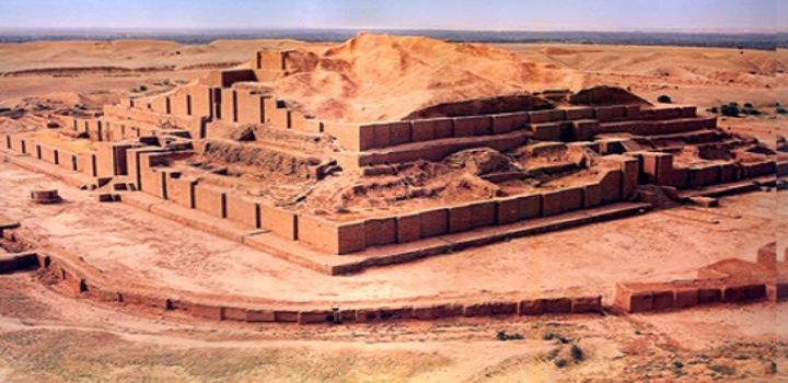
Located in ancient Elam (today Khuzestan province in southwest Iran), Tchogha Zanbil (Dur-Untash, or City of Untash, in Elamite) was founded by the Elamite king Untash-Napirisha (1275-1240 BCE) as the religious centre of Elam. The principal element of this complex is an enormous ziggurat dedicated to the Elamite divinities Inshushinak and Napirisha. It is the largest ziggurat outside of Mesopotamia and the best preserved of this type of stepped pyramidal monument. The archaeological site of Tchogha Zanbil is an exceptional expression of the culture, beliefs, and ritual traditions of one of the oldest indigenous peoples of Iran. Our knowledge of the architectural development of the middle Elamite period (1400-1100 BCE) comes from the ruins of Tchogha Zanbil and of the capital city of Susa 38 km to the north-west of the temple).
The archaeological site of Tchogha Zanbil covers a vast, arid plateau overlooking the rich valley of the river Ab-e Diz and its forests. A “sacred city” for the king’s residence, it was never completed and only a few priests lived there until it was destroyed by the Assyrian king Ashurbanipal about 640 BCE. The complex was protected by three concentric enclosure walls: an outer wall about 4 km in circumference enclosing a vast complex of residences and the royal quarter, where three monumental palaces have been unearthed (one is considered a tomb-palace that covers the remains of underground baked-brick structures containing the burials of the royal family); a second wall protecting the temples (Temenus); and the innermost wall enclosing the focal point of the ensemble, the ziggurat.
The ziggurat originally measured 105.2 m on each side and about 53 m in height, in five levels, and was crowned with a temple. Mud brick was the basic material of the whole ensemble. The ziggurat was given a facing of baked bricks, a number of which have cuneiform characters giving the names of deities in the Elamite and Akkadian languages. Though the ziggurat now stands only 24.75 m high, less than half its estimated original height, its state of preservation is unsurpassed. Studies of the ziggurat and the rest of the archaeological site of Tchogha Zanbil containing other temples, residences, tomb-palaces, and water reservoirs have made an important contribution to our knowledge about the architecture of this period of the Elamites, whose ancient culture persisted into the emerging Achaemenid (First Persian) Empire, which changed the face of the civilised world at that time.
Criterion (iii): The ruins of Susa and of Tchogha Zanbil are the sole testimonies to the architectural development of the middle Elamite period (1400-1100 BCE).
Criterion (iv): The ziggurat at Tchogha Zanbil remains to this day the best preserved monument of this type and the largest outside of Mesopotamia.
Integrity
Within the boundaries of the property are located all the elements and components necessary to express the Outstanding Universal Value of the property, including, among others, the concentric walls, the royal quarter, the temples, various dependencies, and the ziggurat. Almost none of the various architectural elements and spaces has been removed or suffered major damage. The integrity of the landscape and lifestyle of the indigenous communities has largely been protected due to being away from urban areas.
Identified threats to the integrity of the property include heavy rainfalls, which can have a damaging effect on exposed mud-brick structures; a change in the course of the river Ab-e Diz, which threatens the outer wall; sugar cane cultivation and processing, which have altered traditional land use and increased air and water pollution; and deforestation of the river valleys. Visitors were banned from climbing the ziggurat in 2002, and a lighting system has been installed and guards stationed at the site to protect it from illegal excavations.
Authenticity
The historical monuments of the archaeological site of Tchogha Zanbil are authentic in terms of their forms and design, materials and substance, and locations and setting. Several conservation measures have been undertaken since the original excavations of the site between 1946 and 1962, but they have not usually disturbed its historical authenticity.
Protection and management requirements
Tchogha Zanbil was registered in the national list of Iranian monuments as item no. 895 on 26 January 1970. Relevant national laws and regulations concerning the property include the National Heritage Protection Law (1930, updated 1998) and the 1980 Legal bill on preventing clandestine diggings and illegal excavations. The inscribed World Heritage property, which is owned by the Government of Iran, and its buffer zone are administered by the Iranian Cultural Heritage, Handicrafts and Tourism Organization (which is administered and funded by the Government of Iran). A Management Plan was prepared in 2003 and has since been implemented. Planning for tourism management, landscaping, and emergency evacuation for the property has been accomplished and implementation was in progress in 2013. A research centre has undertaken daily, monthly, and annual monitoring of the property since 1998. Financial resources for Tchogha Zanbil are provided through national budgets.
Conservation activities have been undertaken within a general framework, including development of scientific research programs; comprehensive conservation of the property and its natural-historical context; expansion of the conservation program to the surrounding environment; concentration on engaging the public and governmental organizations and agencies; and according special attention to programs for training and presentation (with the aim of developing cultural tourism) based on sustainable development. Objectives include research programs and promotion of a conservation management culture; scientific and comprehensive conservation of the property and surrounding area; and development of training and introductory programmes.
Sustaining the Outstanding Universal Value of the property over time will require creating a transparent and regular funding system, employing efficient and sustainable management systems, supporting continuous protection and presentation, enjoying the public support and giving life to the property, adopting a “minimum intervention” approach, and respecting the integrity and authenticity of the property and its surrounding environment. In addition, any outstanding recommendations of past expert missions to the property should be addressed.
[:de]
Die Ruinen der heiligen Stadt des Königreichs Elam,die von drei riesigen konzentrischen Mauern umgeben sind, befinden sich in Tschogha Zambil.Die Stadt wurde 1250 v.Chr. gegründet,und blieb unvollendet, nachdem sie von Assurbanipal überfallen worden war, wie die tausenden von unbenutzten Steinen auf der Baustelle zeigten.
Kurze Zusammensetzung
Tschogha Zambil(Dur-untash,die Stadt der Untash) liegt im alten Elam (heute Khuzestan eine Provinz im Südwesten Irans).Sie wurde vom elamitischen König Untash-Napirisha (1275-1240 v. Chr.) als religiöses Zentrum von Elam gegründet. Das Hauptelement dieses Komplexes ist eine riesige Zikkurat, die den elamitischen Gottheiten Inshushinak und Napirisha gewidmet ist. Es ist die größte Zikkurat außerhalb von Mesopotamien und das am besten erhaltene dieser Art von abgestuften Pyramiden-Denkmal. Die archäologische Stätte von Tschogha Zambil ist ein außergewöhnlicher Ausdruck der Kultur, des Glaubens und der rituellen Traditionen eines der ältesten indigenen Völker des Irans. Unser Wissen über die architektonische Entwicklung der mittleren elamischen Periode (1400-1100 v. Chr.) stammen aus den Ruinen von Tschogha Zambil und der Hauptstadt Susa 38 km nordwestlich des Tempels.
Die archäologische Stätte von Tschogha Zambil erstreckt sich über eine weite, trockene Hochebene mit Blick auf das fruchtbare Tal des Flusses Ab-e Diz und seine Wälder. Als “heilige Stadt” für die Residenz des Königs wurde sie nie vollendet . Nur wenige Priester lebten dort, bis sie etwa 640 v. Chr. Vom assyrischen König Assurbanipal zerstört wurde. Der Komplex wurde durch drei konzentrische Umfassungsmauern geschützt.Eine Außenmauer von etwa 4 km Umfang umfasste einen großen Komplex von Residenzen und das königliche Viertel, wo drei monumentale Paläste ausgegraben wurden(einer gilt als ein Grabpalast,der die Überreste des Untergrunds bedeckt). Backsteinstrukturen mit Bestattungen der königlichen Familie, eine zweite Mauer, die die Tempel schützt (Temenus), und die innerste Wand umschließt den Brennpunkt des Ensembles, die Zikkurat.
Die Zikkurat hatte ursprünglich 105,2 m auf jeder Seite und etwa 53 m Höhe in fünf Ebenen, und wurde mit einem Tempel gekrönt. Lehmziegel waren das Grundmaterial des gesamten Ensembles. Die Zikkurat erhielt eine Verkleidung aus gebrannten Ziegeln, von denen einige keilförmige Schriftzeichen, die die Namen von Gottheiten in den elamischen und akkadischen Sprachen enthalten. Obwohl die Zikkurat jetzt nur 24,75 m hoch ist( weniger als die Hälfte ihrer geschätzten ursprünglichen Höhe), ist ihr Erhaltungszustand unübertroffen. Untersuchungen der Zikkurat und der übrigen archäologischen Fundstätte von Tschogha Zambil mit anderen Tempeln, Residenzen, Grabpalästen und Wasserreservoiren haben einen wichtigen Beitrag zu unserem Wissen über die Architektur dieser Epoche der Elamites und das aufstrebende Achaemeniden Reich, das zu dieser Zeit das Gesicht der zivilisierten Welt veränderte,geleistet.
Kriterium (iii): Die Ruinen von Susa und Tschogha Zambil sind die einzigen Zeugnisse für die architektonische Entwicklung der mittleren elamischen Periode (1400-1100 v. Chr.).
Kriterium (iv): Die Zikkurat bei Tschogha Zambil ist bis heute das am besten erhaltene und größte Denkmal dieses Typs außerhalb von Mesopotamien.
Integrität
Innerhalb der Grenzen der Anlage befinden sich alle Elemente und Komponenten, die notwendig sind, um den außergewöhnlichen universellen Wert der Anlage einschließlich unter anderem der konzentrischen Wände, des königlichen Viertels, der Tempel,und der Zikkurat auszudrücken. Fast keines der verschiedenen architektonischen Elemente und Räume wurde entfernt oder schwer beschädigt. Die Integrität der Landschaft und des Lebensstils der indigenen Gemeinschaften wurde größtenteils dadurch geschützt, daß sie nicht in städtischen Gebieten leben.
Zu den identifizierten Bedrohungen für die Integrität des Grundstücks gehören starke Regenfälle, die sich auf freiliegende Lehmziegelstrukturen schädlich auswirken können,eine Veränderung im Verlauf des Flusses Ab-e Diz, der die Außenmauer bedroht, Zuckerrohranbau und -verarbeitung, die erhöhte Luft- und Wasserverschmutzung, und Abholzung der Flußtäler. Im Jahr 2002 wurde die Zikkurat zu besteigen verboten.Es wurde ein Beleuchtungssystem installiert und Wachen stationiert, um sie vor illegalen Ausgrabungen zu schützen.
Authentizität
Die historischen Denkmäler der archäologischen Stätte von Tschogha Zambil sind authentisch in Bezug auf ihre Formen und Design, Materialien und Substanz, und Orte und Umgebung. Seit den ursprünglichen Ausgrabungen des Geländes zwischen 1946 und 1962 wurden mehrere Erhaltungsmaßnahmen durchgeführt, die jedoch ihre historische Authentizität nicht gestört haben.
Schutz- und Managementanforderungen
Tschogha Zambil wurde in die nationale Liste der iranischen Monumente als Artikel Nr. 1 eingetragen. Die entsprechenden nationalen Gesetze und Vorschriften bezüglich des Grundstücks umfassen das Gesetz zum Schutz des nationalen Erbes (1930, aktualisiert 1998) und das Gesetzes von 1980 über die Verhinderung von illegalen Ausgrabungen. Die denkmalgeschützte Welterbestätte, die der iranischen Regierung gehört, werden von der iranischen Kultur-, Handwerks- und Tourismusorganisation verwaltet. Ein Managementplan wurde 2003 erstellt und seitdem umgesetzt. Die Planung für das Tourismusmanagement, die Landschaftsgestaltung und die Notfallevakuierung der Anlage wurde abgeschlossen ,und die Umsetzung wurde 2013 durchgeführt. Ein Forschungszentrum hat seit 1998 tägliche, monatliche und jährliche Überwachung der Anlage durchgeführt. Die finanziellen Mittel für Tschogha Zambil werden von nationalen Haushalten bereitgestellt .Naturschutzmaßnahmen wurden in einem allgemeinen Rahmen, einschließlich der Entwicklung von Forschungsprogrammen, umfassende Erhaltung der Anlage und ihres naturhistorischen Kontextes ,Erweiterung des Schutzprogramms auf die Umgebung,Konzentration auf die Einbeziehung der Öffentlichkeit und der staatlichen Organisationen und Agenturen durchgeführt. Zu den Zielen gehören Forschungsprogramme, die Förderung einer Kultur des Naturschutzmanagements,wissenschaftliche Erhaltung des Grundstücks und der Umgebung, und Entwicklung von Trainings- und Einführungsprogrammen.
Um den außergewöhnlichen universellen Wert der Immobilie im Laufe der Zeit aufrecht zu erhalten, muss ein transparentes und regelmäßiges Finanzierungssystem geschaffen werden, das effiziente und nachhaltige Managementsysteme verwendet, fortwährenden Schutz und Präsentation unterstützt, die öffentliche Unterstützung genießt und der Immobilie Leben einhaucht. Darüber hinaus sollten alle ausstehenden Empfehlungen früherer Expertenmissionen auf dem Grundstück behandelt werden.
[:fr][vc_row][vc_column][vc_column_text]
TCHOGHA ZANBIL
Les ruines de la ville sainte du royaume d’Elam, entourées de trois énormes murs concentriques, se trouvent à Tchogha Zanbil. Fondée c. 1250 av. J.-C., la ville reste inachevée après l’invasion d’Asurbanipal, comme le montrent les milliers de briques inutilisées laissées sur le site.
Tchogha Zanbil (Dur-Untash, ou la ville d’Unash, en élamite), située dans l’ancienne Élam (aujourd’hui province du Khuzestan, sud-ouest de l’Iran), a été fondée par le roi élamite, Untash-Napirisha (1275-1240 av. J.-C.), en tant que centre religieux d’Elam. L’élément principal de ce complexe est une énorme ziggourat dédiée aux divinités élamites Inshushinak et Napirisha. C’est la plus grande ziggourat en dehors de la Mésopotamie et la mieux conservée de ce type de monument pyramidal en gradins. Le site archéologique de Tchogha Zanbil est une expression exceptionnelle de la culture, des croyances et des traditions rituelles de l’un des plus anciens peuples autochtones d’Iran. Notre connaissance du développement architectural du milieu de la période élamite (1400-1100 av. J.-C.) provient des ruines de Tchogha Zanbil et de la capitale, Susa, située à 38 km au nord-ouest du temple.
Le site archéologique de Tchogha Zanbil couvre un vaste plateau aride surplombant la riche vallée de la rivière Ab-e Diz et ses forêts. Cité sacrée de la résidence du roi, elle n’a jamais été achevée et seuls quelques prêtres y ont vécu jusqu’à sa destruction par le roi assyrien Assurbanipal vers 640 av. Le complexe était protégé par trois murs d’enceinte concentriques: un mur extérieur d’environ 4 km de circonférence renfermant un vaste ensemble de résidences et le quartier royal, où trois palais monumentaux ont été découverts (l’un est considéré comme un palais des tombes qui recouvre les restes souterrains structures en briques cuites contenant les sépultures de la famille royale); un second mur protégeant les temples (Temenus); et le mur le plus profond entourant le point focal de l’ensemble, la ziggourat.
La ziggourat mesurait à l’origine 105,2 m de chaque côté et environ 53 m de haut, sur cinq niveaux, et était couronnée d’un temple. La brique de boue était le matériau de base de l’ensemble. La ziggourat a reçu un revêtement de briques cuites, dont un certain nombre ont des caractères cunéiformes donnant les noms de divinités en langues élamite et akkadienne. Bien que la ziggourat n’ait plus que 24,75 m de hauteur, soit moins de la moitié de sa hauteur initiale estimée, son état de conservation est inégalé. Les études de la ziggourat et du reste du site archéologique de Tchogha Zanbil contenant d’autres temples, résidences, palais des tombes et réservoirs d’eau ont grandement contribué à la connaissance que nous avons de l’architecture de cette période des Élamites, dont la culture ancienne a perduré l’émergence d’un empire achéménide (premier perse), qui changea la face du monde civilisé à cette époque.
Critère (i): Les ruines de Suse et de Tchogha Zanbil sont les seuls témoignages du développement architectural de la période du mi-élamite (1400-1100 av. J.-C.).
Critère (ii): La ziggourat de Tchogha Zanbil reste à ce jour le monument le mieux conservé de ce type et le plus grand en dehors de la Mésopotamie.
Intégrité
Tous les éléments et composants nécessaires à l’expression de la valeur universelle exceptionnelle du bien sont localisés à l’intérieur des limites du bien, notamment les murs concentriques, le quartier royal, les temples, diverses dépendances et la ziggurat. Presque aucun des divers éléments et espaces architecturaux n’a été enlevé ou a subi des dommages importants. L’intégrité du paysage et du mode de vie des communautés autochtones a été en grande partie protégée en raison de son éloignement des zones urbaines.
Les menaces identifiées pour l’intégrité du bien incluent les fortes précipitations, qui peuvent avoir un effet néfaste sur les structures en briques crues exposées; un changement dans le cours de la rivière Ab-e Diz, qui menace le mur extérieur; la culture et la transformation de la canne à sucre, qui ont modifié l’utilisation traditionnelle des terres et accru la pollution de l’air et de l’eau; et déforestation des vallées fluviales. Les visiteurs ont été interdits d’escalader la ziggurat en 2002 et un système d’éclairage a été installé et des gardes sont postés sur le site pour le protéger des fouilles illégales.
Authenticité
Les monuments historiques du site archéologique de Tchogha Zanbil sont authentiques par leurs formes et leur conception, leurs matériaux et leur substance, ainsi que par leur emplacement et leur cadre. Plusieurs mesures de conservation ont été entreprises depuis les fouilles initiales du site entre 1946 et 1962, mais elles n’ont généralement pas perturbé son authenticité historique.
Exigences de protection et de gestion
Tchogha Zanbil a été inscrit sur la liste nationale des monuments iraniens sous le numéro d’article. 895, le 26 janvier 1970. Les lois et règlements nationaux pertinents concernant le bien comprennent la loi sur la protection du patrimoine national (1930, mise à jour en 1998) et le projet de loi de 1980 sur la prévention des fouilles clandestines et des fouilles illégales. Le bien inscrit au patrimoine mondial, qui appartient au gouvernement iranien, et sa zone tampon sont administrés par l’Organisation iranienne pour le patrimoine culturel, l’artisanat et le tourisme (qui est administrée et financée par le gouvernement iranien). Un plan de gestion a été préparé en 2003 et a depuis été mis en œuvre. La planification de la gestion du tourisme, de l’aménagement paysager et de l’évacuation d’urgence du bien a été effectuée et sa mise en œuvre était en cours en 2013. Un centre de recherche effectue un suivi quotidien, mensuel et annuel du bien depuis 1998. Les ressources financières pour Tchogha Zanbil sont fournies par budgets nationaux.
Les activités de conservation ont été entreprises dans un cadre général, y compris l’élaboration de programmes de recherche scientifique; conservation intégrale du bien et de son contexte naturel et historique; extension du programme de conservation au milieu environnant; se concentrer sur la participation du public et des organisations et agences gouvernementales; et accorder une attention particulière aux programmes de formation et de présentation (visant à développer le tourisme culturel) basés sur le développement durable. Les objectifs comprennent des programmes de recherche et la promotion d’une culture de gestion de la conservation; conservation scientifique et globale du bien et de ses environs; et développement de programmes de formation et d’initiation.
La préservation de la valeur universelle exceptionnelle du bien à long terme nécessitera la création d’un système de financement transparent et régulier, utilisant des systèmes de gestion efficaces et durables, soutenant une protection et une présentation continues, bénéficiant de l’appui du public et donnant vie au bien, en adoptant une «intervention minimale». respectant l’intégrité et l’authenticité du bien et de son environnement. En outre, toutes les recommandations en suspens émanant de missions d’experts antérieures sur le bien devraient être examinées.
[/vc_column_text][/vc_column][/vc_row][:]