[:en]Persepolis[:de]Persepolis[:fr]Persépolis[:]
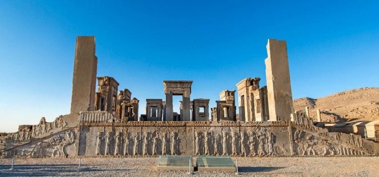
[:en]Founded by Darius I in 518 B.C., Persepolis was the capital of the Achaemenid Empire. It was built on an immense half-artificial, half-natural terrace, where the king of kings created an impressive palace complex inspired by Mesopotamian models. The importance and quality of the monumental ruins make it a unique archaeological site.
Brief Synthesis
Persepolis, whose magnificent ruins rest at the foot of Kuh-e Rahmat (Mountain of Mercy) in south-western Iran, is among the world’s greatest archaeological sites. Renowned as the gem of Achaemenid (Persian) ensembles in the fields of architecture, urban planning, construction technology, and art, the royal city of Persepolis ranks among the archaeological sites which have no equivalent and which bear unique witness to a most ancient civilization. The city’s immense terrace was begun about 518 BCE by Darius the Great, the Achaemenid Empire’s king. On this terrace, successive kings erected a series of architecturally stunning palatial buildings, among them the massive Apadana palace and the Throne Hall (“Hundred-Column Hall”).
Inspired by Mesopotamian models, the Achaemenid kings Darius I (522-486 BCE), his son Xerxes I (486-465 BCE), and his grandson Artaxerxes I (465-424 BCE) built a splendid palatial complex on an immense half-natural, half-artificial terrace. This 13-ha ensemble of majestic approaches, monumental stairways, throne rooms (Apadana), reception rooms, and dependencies is classified among the world’s greatest archaeological sites. The terrace is a grandiose architectural creation, with its double flight of access stairs, walls covered by sculpted friezes at various levels, contingent Assyrianesque propylaea (monumental gateway), gigantic sculpted winged bulls, and remains of large halls. By carefully engineering lighter roofs and using wooden lintels, the Achaemenid architects were able to use a minimal number of astonishingly slender columns to support open area roofs. Columns were topped with elaborate capitals; typical was the double-bull capital where, resting on double volutes, the forequarters of two kneeling bulls, placed back-to-back, extend their coupled necks and their twin heads directly under the intersections of the beams of the ceiling.
Persepolis was the seat of government of the Achaemenid Empire, though it was designed primarily to be a showplace and spectacular centre for the receptions and festivals of the kings and their empire. The terrace of Persepolis continues to be, as its founder Darius would have wished, the image of the Achaemenid monarchy itself, the summit where likenesses of the king reappear unceasingly, here as the conqueror of a monster, there carried on his throne by the downtrodden enemy, and where lengthy cohorts of sculpted warriors and guards, dignitaries, and tribute bearers parade endlessly.
Criterion (i): The terrace of Persepolis, with its double flight of access stairs, its walls covered by sculpted friezes at various levels, contingent Assyrianesque propylaea, the gigantic winged bulls, and the remains of large halls, is a grandiose architectural creation. The studied lightening of the roofing and the use of wooden lintels allowed the Achaemenid architects to use, in open areas, a minimum number of astonishingly slender columns (1.60 metres in diameter vis-à-vis a height of about 20 metres). They are surmounted by typical capitals where, resting on double volutes, the forequarters of two kneeling bulls, placed back-to-back, extend their coupled necks and their twin heads, directly under the intersections of the beams of the ceiling.
Criterion (iii): This ensemble of majestic approaches, monumental stairways, throne rooms (Apadana), reception rooms, and annex buildings is classified among the world’s greatest archaeological sites, among those which have no equivalent and which bear witness of a unique quality to a most ancient civilization.
Criterion (vi): The terrace of Persepolis continues to be, as its founder Darius would have wished, the image of the Achaemenid monarchy itself, the summit where likenesses of the king reappear unceasingly, here as the conqueror of a monster, there carried on his throne by the downtrodden enemy, and where lengthy cohorts of sculpted warriors and guards, dignitaries, and tribute bearers parade endlessly.
Integrity
Within the boundaries of the property are located the known elements and components necessary to express the Outstanding Universal Value of the property, including the archaeological remains of the terrace and of its related royal palaces and buildings.
The most significant identified challenge to the integrity of the property and its buffer zone is controlling its borders and boundaries against agricultural, industrial, and constructional development. The principal potential threats are the growth of Marvdasht town, new village developments, and the arrival of polluting industries. These threats are considered to be increasing.
Authenticity
The archaeological ruins at Persepolis are authentic in terms of their locations and setting, materials and substance, and forms and design. The present location of the Persepolis terrace and its related buildings has not changed over the course of time. Restoration work has carefully respected the authenticity of the monuments, utilizing traditional technology and materials in harmony with the ensemble. No changes have been made to the general plan of Persepolis. Moreover, there are no modern reconstructions at Persepolis; the remains of all the monuments are authentic.
Protection and management requirements
The Persepolis Ensemble was registered in the national list of Iranian monuments as item no. 20 on the 24th of the month Shahrivar, 1310 SAH (15 September 1931). Relevant national laws and regulations concerning the property include the National Heritage Protection Law (1930, updated 1998) and the 1980 Legal bill on preventing clandestine diggings and illegal excavations. The inscribed World Heritage property, which is owned by the Government of Iran, and its buffer zone are under the legal protection and management of the Iranian Cultural Heritage, Handicrafts and Tourism Organization (which is administered and funded by the Government of Iran). The property and buffer zone are also under a regional master plan with its own regulations. A management plan covering the identification of borders, buffer zone, land ownership, conservation priorities, and time-tabled management interventions was introduced in 2001. Persepolis Research Base, a management and conservation office established in Persepolis in 2001, is responsible for the investigation, conservation, restoration, reorganization, and presentation of the property. Training and skills upgrading are offered by the office in cooperation with universities and scientific institutes in Iran and abroad. Financial resources for Persepolis are provided through national and provincial budgets, and site admission fees.
Sustaining the Outstanding Universal Value of the property over time will require creating monitoring and evaluation systems for air pollutants, weathering, and environmental factors; controlling the borders and boundaries of the property against agricultural, industrial, and constructional development; developing indicators for measuring the effects of the potential growth and development of Marvdasht town and new villages; and investigating, evaluating, and eliminating any negative impact such growth and development that may have on the Outstanding Universal Value, integrity or authenticity of the property.[:de]Persepolis wurde 518 von Darius I. Gegründet. Persepolis war die Hauptstadt des Achaimenidenreiches. Es wurde auf einer riesigen halb-künstlichen, halb-natürlichen Terrasse ,wo der König der Könige einen eindrucksvollen Palastkomplex schuf, errichtet .Der wurde von mesopotamischen Modellen inspiriert. Die Bedeutung und Qualität der monumentalen Ruinen machen es zu einer einzigartigen archäologischen Stätte.
Kurze Zusammensetzung Persepolis, dessen prachtvolle Ruinen am Fuße des Kuh-e Rahmat (Berg der Barmherzigkeit) im südwestlichen Iran liegen, gehört zu den größten archäologischen Stätten der Welt. Die königliche Stadt Persepolis gilt als das Juwel achaimenidischer (persischer) Zusammensetzung von Architektur, Stadtplanung, Bautechnik und Kunst. Sie gehört zu den archäologischen Stätten, die kein gleichwertiges Beispiel haben, und die ein einzigartiges Zeugnis einer ältesten Zivilisation sind. Der Bau der immense Terrasse der Stadt wurde um 518 v. Chr. von Darius dem Großen begonnen. Auf dieser Terrasse errichteten aufeinanderfolgende Könige eine Reihe architektonisch beeindruckender palastartiger Gebäude, darunter der massive Apadana-Palast und der Thronsaal (“Hundertspaltige Halle”).Inspiriert von mesopotamischen Vorbildern errichteten die Achämeniden-Könige Darius I. (522-486 v. Chr.), sein Sohn Xerxes I. (486-465 v. Chr.) und sein Enkel Artaxerxes I. (465-424 v. Chr.) einen prachtvollen palastartigen Komplex. Dieses 13 Hektar große Zusammensetzung aus majestätischen Ansätzen, monumentalen Treppenhäusern, Thronsälen (Apadana), Empfangsräumen und Nebengebäuden gehört zu den größten archäologischen Stätten der Welt. Die Terrasse ist eine grandiose architektonische Schöpfung, mit einer doppelten Flucht der Zugangstreppen. Wände sind mit geformten Friesen auf verschiedenen Niveaus bedeckt,und mit Kontingent Assyrianese Propyläe (monumentales Tor), riesige gemeißelte geflügelte Stiere bestückt. Durch die sorgfältige Konstruktion hellerer Dächer und die Verwendung von Holzstürzen konnten die Architekten der Achämeniden eine minimale Anzahl von erstaunlich schlanken Säulen für offene Dächer verwenden. Die Säulen waren mit kunstvollen Kapitellen versehen. Typisch war das Doppelbullenkapital, die auf zwei Voluten ruhenden Vorderteile Rücken an Rücken angeordnet waren, und ihre gekoppelten Hälse und ihre Zwillingsköpfe direkt unter den Schnittpunkten der Deckenbalken ausstreckten.
Persepolis war der Sitz der Regierung des Achämenidenreiches, obwohl es in erster Linie als Schauplatz und spektakuläres Zentrum für die Empfänge und Feste der Könige gedacht war. Die Terrasse von Persepolis ist, wie ihr Gründer Darius sich gewünscht hätte, das Bild der achämenidischen Monarchie selbst.Auf dem Gipfel tauchen unaufhörlich Bildnisse des Königs wieder auf,die als Bezwinger eines Monstrums, auf dem Thron der Unterdrückten Feind, und wo lange Kohorten von gemeißelten Kriegern und Wachen, Würdenträgern und Tribünenträgern endlos paradieren.
Kriterium (i): Die Terrasse von Persepolis, mit ihren doppelten Treppenfluchten, ihren mit Relieffriesen verzierten Wänden auf verschiedenen Ebenen, kontingenten assyrischen Propyläen, den riesigen Flügelbullen und den Überresten großer Hallen ist eine grandiose architektonische Schöpfung. Die studierte Aufhellung des Daches und die Verwendung von Holzstürzen erlaubten den Architekten der Achämeniden in offenen Gebieten eine minimale Anzahl von erstaunlich schlanken Säulen zu verwenden (1,60 Meter im Durchmesser gegenüber einer Höhe von etwa 20 Metern)..
Kriterium (iii): Dieses Ensemble aus majestätischen Ansätzen, monumentalen Treppenhäusern, Thronsälen (Apadana), Empfangsräumen und Nebengebäuden gehört zu den größten archäologischen Stätten der Welt, zu denen es keine Entsprechungen gibt .
Kriterium (vi): Die Terrasse von Persepolis bleibt, wie ihr Gründer Darius sich gewünscht hätte, das Bild der Achämeniden-Monarchie selbst.Auf dem Gipfel tauchen unaufhörlich Bildnisse des Königs wieder auf.
Integrität
Innerhalb der Grenzen der Anlage befinden sich die bekannten Elemente und Komponenten, die notwendig sind, um den außergewöhnlichen universellen Wert des Eigentums einschließlich der archäologischen Überreste der Terrasse und der damit verbundenen königlichen Paläste und Gebäude auszudrücken.Die wichtigste identifizierte Herausforderung für die Integrität der Anlage ist die Kontrolle seiner Grenzen gegenüber der landwirtschaftlichen, industriellen und baulichen Entwicklung. Die größten potentiellen Gefahren sind das Wachstum der Stadt Marvdasht, neue Dorfentwicklungen und die Ankunft von umweltschädlichen Industrien. Diese Bedrohungen werden als zunehmend angesehen.
Authentizität
Die archäologischen Ruinen in Persepolis sind authentisch in Bezug auf ihre Lage und Umgebung, Materialien und Substanz sowie Formen und Design. Der heutige Standort der Persepolis-Terrasse und der dazugehörigen Gebäude haben sich im Laufe der Zeit nicht verändert. Restaurierungsarbeiten haben die Authentizität der Denkmäler sorgfältig respektiert, wobei traditionelle Techniken und Materialien in Harmonie mit dem Ensemble verwendet wurden. Am Generalplan von Persepolis wurden keine Änderungen vorgenommen. Außerdem gibt es in Persepolis keine modernen Rekonstruktionen. Die Überreste aller Denkmäler sind authentisch.
Schutz- und Managementanforderungen
Das Persepolis Ensemble wurde in die nationale Liste der iranischen Monumente als Nr. 20 am 24. des Monats Shahrivar, 1310 SAH(15. September 1931) registriert. Zu den maßgeblichen nationalen Gesetzen und Vorschriften in Bezug auf das Grundstück gehören das Gesetz zum Schutz des nationalen Erbes (1930, aktualisiert 1998) und das Gesetzesgesetz von 1980 zur Verhinderung von illegalen Ausgrabungen. Das eingeschriebene Welterbe ist das Eigentum der iranischen Regierung .Seine Pufferzone stehen unter dem rechtlichen Schutz und der Verwaltung der iranischen Organisation für Kulturerbe, Handwerk und Tourismus (die von der iranischen Regierung verwaltet und finanziert wird). Die Anlage und die Pufferzone unterliegen ebenfalls einem regionalen Masterplan mit eigenen Vorschriften. Im Jahr 2001 wurde ein Bewirtschaftungsplan, der die Festlegung von Grenzen, Pufferzonen, Landbesitz, Schutzprioritäten und zeitgesteuerte Managementinterventionen vorsieht,eingefürt.Der Forschungsbasis von Persepolis ist ein in 2001 eingerichtetes Management- und Naturschutzbüro, das für die Untersuchung, Konservierung, Restaurierung, Reorganisation und Präsentation der Immobilie verantwortlich ist. Schulungen und Qualifizierungsmaßnahmen werden vom Büro in Zusammenarbeit mit Universitäten und wissenschaftlichen Instituten im Iran und im Ausland angeboten. Die finanziellen Mittel für Persepolis werden aus den nationalen und regionalen Budgets und den Gebühren für die Aufnahme vor Ort bereitgestellt.
Um den außergewöhnlichen universellen Wert der Immobilie im Laufe der Zeit aufrechtzuerhalten, müssen Überwachungs- und Bewertungssysteme für Luftschadstoffe, Verwitterung und Umweltfaktoren geschaffen werden. Kontrolle der Grenzen der Anlage gegen landwirtschaftliche, industrielle und bauliche Entwicklung benötigen Entwicklung von Indikatoren zur Messung der Auswirkungen des potenziellen Wachstums und der Entwicklung der Stadt Marvdasht und neuer Dörfer.[:fr][vc_row][vc_column][vc_column_text]Fondée par Darius Ier en 518 av. J.-C., Persépolis était la capitale de l’empire des Achéménides. Il a été construit sur une immense terrasse mi-artificielle, mi-naturelle, où le roi des rois a créé un impressionnant complexe de palais inspiré des modèles mésopotamiens. L’importance et la qualité des ruines monumentales en font un site archéologique unique.
Brève synthèse
Persépolis, dont les ruines magnifiques reposent au pied de Kuh-e Rahmat (montagne de la Miséricorde) dans le sud-ouest de l’Iran, est l’un des plus importants sites archéologiques du monde. Reconnue comme le joyau des ensembles achéménides (persans) dans les domaines de l’architecture, de l’urbanisme, de la technologie de la construction et des arts, la ville royale de Persépolis figure parmi les sites archéologiques sans équivalent et qui témoignent de manière unique d’une civilisation très ancienne. L’immense terrasse de la ville fut commencée vers 518 avant notre ère par Darius le Grand, roi de l’empire achéménide. Sur cette terrasse, les rois successifs ont érigé une série de palais somptueux sur le plan architectural, parmi lesquels l’imposant palais Apadana et la salle du trône (la «salle aux cent colonnes»).
Inspirés par les modèles mésopotamiens, les rois achéménides Darius Ier (522-486 AEC), son fils Xerxès Ier (486-465 AEC) et son petit-fils Artaxerxès Ier (465-424 AEC) construisirent un splendide complexe palatial sur un immense terrasse semi-artificielle. Cet ensemble de 13 hectare d’approches majestueuses, d’escaliers monumentaux, de salles du trône (Apadana), de salles de réception et de dépendances est classé parmi les plus grands sites archéologiques du monde. La terrasse est une création architecturale grandiose, avec son double escalier d’accès, ses murs couverts de frises sculptées à divers niveaux, ses propylées assyrianesques (porte monumentale), ses gigantesques taureaux ailés sculptés et ses vestiges de grandes salles. En construisant soigneusement des toits plus légers et en utilisant des linteaux en bois, les architectes achéménides ont pu utiliser un nombre minimal de colonnes étonnamment fines pour soutenir les toits à ciel ouvert. Les colonnes étaient surmontées de chapiteaux élaborés; La capitale des doubles taureaux est typique: là où deux taureaux agenouillés, posés dos à dos, reposent sur leur double volute, étendent leur cou et leur tête jumelées directement sous les intersections des poutres du plafond.
Persépolis était le siège du gouvernement de l’empire achéménide, bien qu’il ait été conçu avant tout pour être un lieu de spectacle et un centre spectaculaire pour les réceptions et les fêtes des rois et de leur empire.
Critère (i): La terrasse de Persépolis, avec son double escalier d’accès, ses murs recouverts de frises sculptées à divers niveaux, ses propylées assyrianesques, ses gigantesques taureaux ailés et les vestiges de vastes salles, est une création architecturale grandiose. L’allégement étudié de la couverture et l’utilisation de linteaux en bois ont permis aux architectes achéménides d’utiliser un nombre minimal de colonnes étonnamment fines (1,60 m de diamètre pour une hauteur d’environ 20 m) dans les espaces dégagés. Ils sont surmontés de chapiteaux typiques où, reposant sur une double volute, les membres antérieurs de deux taureaux agenouillés, placés dos à dos, étendent leur cou et leurs têtes jumelées, directement sous les intersections des poutres du plafond.
Critère (ii): Cet ensemble d’approches majestueuses, d’escaliers monumentaux, de salles du trône (Apadana), de salles de réception et de bâtiments annexes est classé parmi les plus grands sites archéologiques du monde, parmi ceux qui n’ont pas d’équivalent et qui témoignent d’une qualité unique. une civilisation la plus ancienne.
Critère (iii): La terrasse de Persépolis continue d’être, comme son fondateur Darius l’aurait souhaité, l’image de la monarchie achéménide elle-même, le sommet où réapparaissent sans cesse les images du roi, ici en tant que conquérant d’un monstre. son trône par l’ennemi opprimé, et où défilent sans fin de longues cohortes de guerriers et de gardes sculptés, de dignitaires et de porteurs de tributs.
Intégrité
Les éléments et composants connus permettant d’exprimer la valeur universelle exceptionnelle du bien, y compris les vestiges archéologiques de la terrasse et des palais et bâtiments royaux connexes, sont situés à l’intérieur des limites du bien.
Le principal défi identifié pour l’intégrité du bien et de sa zone tampon consiste à contrôler ses frontières et ses frontières contre le développement agricole, industriel et de la construction. Les principales menaces potentielles sont la croissance de la ville de Marvdasht, les nouveaux développements de villages et l’arrivée d’industries polluantes. Ces menaces sont considérées comme en augmentation.
Authenticité
Les ruines archéologiques de Persépolis sont authentiques en termes d’emplacement et de cadre, de matériaux et de substance, de formes. L’emplacement actuel de la terrasse de Persépolis et de ses bâtiments connexes n’a pas changé au fil du temps. Les travaux de restauration ont soigneusement respecté l’authenticité des monuments en utilisant des technologies et des matériaux traditionnels en harmonie avec l’ensemble. Aucune modification n’a été apportée au plan général de Persépolis. De plus, il n’y a pas de reconstructions modernes à Persépolis; les vestiges de tous les monuments sont authentiques.
Exigences de protection et de gestion
L’ensemble de Persépolis a été inscrit sur la liste nationale des monuments iraniens au titre de l’article no. 20 le 15 septembre 1931. Les lois et réglementations nationales pertinentes concernant le bien comprennent la loi sur la protection du patrimoine national (1930, mise à jour en 1998) et le projet de loi de 1980 sur la prévention des fouilles clandestines et des fouilles illégales. Le bien inscrit au patrimoine mondial, qui appartient au gouvernement iranien, et sa zone tampon relèvent de la protection juridique et de la gestion de l’Organisation iranienne pour le patrimoine culturel, l’artisanat et le tourisme (qui est administrée et financée par le gouvernement iranien). Le bien et la zone tampon font également l’objet d’un plan directeur régional doté de sa propre réglementation. Un plan de gestion couvrant l’identification des frontières, la zone tampon, la propriété foncière, les priorités de conservation et les interventions de gestion programmées a été introduit en 2001. Base de recherche Persépolis, un bureau de gestion et de conservation créé à Persepolis en 2001, est responsable de l’enquête, conservation, restauration, réorganisation et présentation du bien. Le bureau offre une formation et une mise à niveau des compétences en coopération avec des universités et des instituts scientifiques en Iran et à l’étranger. Les ressources financières pour Persépolis proviennent des budgets national et provincial, ainsi que des frais d’admission sur les sites.
Le maintien de la valeur universelle exceptionnelle du bien au fil du temps nécessitera la création de systèmes de surveillance et d’évaluation des polluants atmosphériques, des conditions climatiques et des facteurs environnementaux; contrôler les limites et les limites du bien contre le développement agricole, industriel et de la construction; développer des indicateurs pour mesurer les effets de la croissance potentielle et du développement de la ville de Marvdasht et des nouveaux villages; et étudier, évaluer et éliminer tout impact négatif que cette croissance et ce développement pourraient avoir sur la valeur universelle exceptionnelle, l’intégrité ou l’authenticité du bien.
.[/vc_column_text][/vc_column][/vc_row][:]
[:en]Tchogha Zanbil[:de]Tschogha Zambil[:fr]Tchogha Zanbil[:]
[:en]
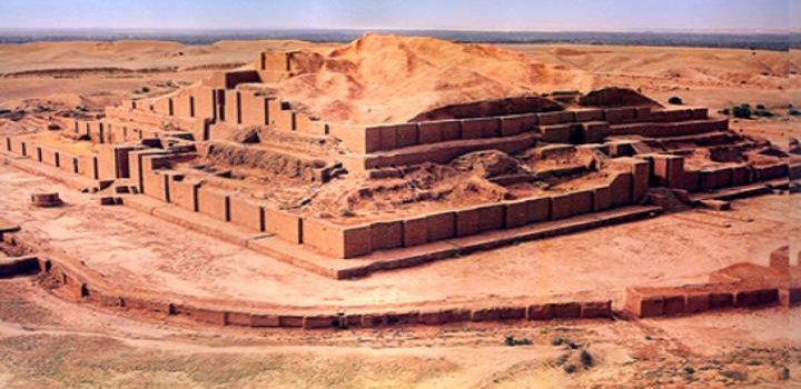
The ruins of the holy city of the Kingdom of Elam, surrounded by three huge concentric walls, are found at Tchogha Zanbil. Founded c. 1250 B.C., the city remained unfinished after it was invaded by Ashurbanipal, as shown by the thousands of unused bricks left at the site.
Brief Synthesis
Located in ancient Elam (today Khuzestan province in southwest Iran), Tchogha Zanbil (Dur-Untash, or City of Untash, in Elamite) was founded by the Elamite king Untash-Napirisha (1275-1240 BCE) as the religious centre of Elam. The principal element of this complex is an enormous ziggurat dedicated to the Elamite divinities Inshushinak and Napirisha. It is the largest ziggurat outside of Mesopotamia and the best preserved of this type of stepped pyramidal monument. The archaeological site of Tchogha Zanbil is an exceptional expression of the culture, beliefs, and ritual traditions of one of the oldest indigenous peoples of Iran. Our knowledge of the architectural development of the middle Elamite period (1400-1100 BCE) comes from the ruins of Tchogha Zanbil and of the capital city of Susa 38 km to the north-west of the temple).
The archaeological site of Tchogha Zanbil covers a vast, arid plateau overlooking the rich valley of the river Ab-e Diz and its forests. A “sacred city” for the king’s residence, it was never completed and only a few priests lived there until it was destroyed by the Assyrian king Ashurbanipal about 640 BCE. The complex was protected by three concentric enclosure walls: an outer wall about 4 km in circumference enclosing a vast complex of residences and the royal quarter, where three monumental palaces have been unearthed (one is considered a tomb-palace that covers the remains of underground baked-brick structures containing the burials of the royal family); a second wall protecting the temples (Temenus); and the innermost wall enclosing the focal point of the ensemble, the ziggurat.
The ziggurat originally measured 105.2 m on each side and about 53 m in height, in five levels, and was crowned with a temple. Mud brick was the basic material of the whole ensemble. The ziggurat was given a facing of baked bricks, a number of which have cuneiform characters giving the names of deities in the Elamite and Akkadian languages. Though the ziggurat now stands only 24.75 m high, less than half its estimated original height, its state of preservation is unsurpassed. Studies of the ziggurat and the rest of the archaeological site of Tchogha Zanbil containing other temples, residences, tomb-palaces, and water reservoirs have made an important contribution to our knowledge about the architecture of this period of the Elamites, whose ancient culture persisted into the emerging Achaemenid (First Persian) Empire, which changed the face of the civilised world at that time.
Criterion (iii): The ruins of Susa and of Tchogha Zanbil are the sole testimonies to the architectural development of the middle Elamite period (1400-1100 BCE).
Criterion (iv): The ziggurat at Tchogha Zanbil remains to this day the best preserved monument of this type and the largest outside of Mesopotamia.
Integrity
Within the boundaries of the property are located all the elements and components necessary to express the Outstanding Universal Value of the property, including, among others, the concentric walls, the royal quarter, the temples, various dependencies, and the ziggurat. Almost none of the various architectural elements and spaces has been removed or suffered major damage. The integrity of the landscape and lifestyle of the indigenous communities has largely been protected due to being away from urban areas.
Identified threats to the integrity of the property include heavy rainfalls, which can have a damaging effect on exposed mud-brick structures; a change in the course of the river Ab-e Diz, which threatens the outer wall; sugar cane cultivation and processing, which have altered traditional land use and increased air and water pollution; and deforestation of the river valleys. Visitors were banned from climbing the ziggurat in 2002, and a lighting system has been installed and guards stationed at the site to protect it from illegal excavations.
Authenticity
The historical monuments of the archaeological site of Tchogha Zanbil are authentic in terms of their forms and design, materials and substance, and locations and setting. Several conservation measures have been undertaken since the original excavations of the site between 1946 and 1962, but they have not usually disturbed its historical authenticity.
Protection and management requirements
Tchogha Zanbil was registered in the national list of Iranian monuments as item no. 895 on 26 January 1970. Relevant national laws and regulations concerning the property include the National Heritage Protection Law (1930, updated 1998) and the 1980 Legal bill on preventing clandestine diggings and illegal excavations. The inscribed World Heritage property, which is owned by the Government of Iran, and its buffer zone are administered by the Iranian Cultural Heritage, Handicrafts and Tourism Organization (which is administered and funded by the Government of Iran). A Management Plan was prepared in 2003 and has since been implemented. Planning for tourism management, landscaping, and emergency evacuation for the property has been accomplished and implementation was in progress in 2013. A research centre has undertaken daily, monthly, and annual monitoring of the property since 1998. Financial resources for Tchogha Zanbil are provided through national budgets.
Conservation activities have been undertaken within a general framework, including development of scientific research programs; comprehensive conservation of the property and its natural-historical context; expansion of the conservation program to the surrounding environment; concentration on engaging the public and governmental organizations and agencies; and according special attention to programs for training and presentation (with the aim of developing cultural tourism) based on sustainable development. Objectives include research programs and promotion of a conservation management culture; scientific and comprehensive conservation of the property and surrounding area; and development of training and introductory programmes.
Sustaining the Outstanding Universal Value of the property over time will require creating a transparent and regular funding system, employing efficient and sustainable management systems, supporting continuous protection and presentation, enjoying the public support and giving life to the property, adopting a “minimum intervention” approach, and respecting the integrity and authenticity of the property and its surrounding environment. In addition, any outstanding recommendations of past expert missions to the property should be addressed.
[:de]
Die Ruinen der heiligen Stadt des Königreichs Elam,die von drei riesigen konzentrischen Mauern umgeben sind, befinden sich in Tschogha Zambil.Die Stadt wurde 1250 v.Chr. gegründet,und blieb unvollendet, nachdem sie von Assurbanipal überfallen worden war, wie die tausenden von unbenutzten Steinen auf der Baustelle zeigten.
Kurze Zusammensetzung
Tschogha Zambil(Dur-untash,die Stadt der Untash) liegt im alten Elam (heute Khuzestan eine Provinz im Südwesten Irans).Sie wurde vom elamitischen König Untash-Napirisha (1275-1240 v. Chr.) als religiöses Zentrum von Elam gegründet. Das Hauptelement dieses Komplexes ist eine riesige Zikkurat, die den elamitischen Gottheiten Inshushinak und Napirisha gewidmet ist. Es ist die größte Zikkurat außerhalb von Mesopotamien und das am besten erhaltene dieser Art von abgestuften Pyramiden-Denkmal. Die archäologische Stätte von Tschogha Zambil ist ein außergewöhnlicher Ausdruck der Kultur, des Glaubens und der rituellen Traditionen eines der ältesten indigenen Völker des Irans. Unser Wissen über die architektonische Entwicklung der mittleren elamischen Periode (1400-1100 v. Chr.) stammen aus den Ruinen von Tschogha Zambil und der Hauptstadt Susa 38 km nordwestlich des Tempels.
Die archäologische Stätte von Tschogha Zambil erstreckt sich über eine weite, trockene Hochebene mit Blick auf das fruchtbare Tal des Flusses Ab-e Diz und seine Wälder. Als “heilige Stadt” für die Residenz des Königs wurde sie nie vollendet . Nur wenige Priester lebten dort, bis sie etwa 640 v. Chr. Vom assyrischen König Assurbanipal zerstört wurde. Der Komplex wurde durch drei konzentrische Umfassungsmauern geschützt.Eine Außenmauer von etwa 4 km Umfang umfasste einen großen Komplex von Residenzen und das königliche Viertel, wo drei monumentale Paläste ausgegraben wurden(einer gilt als ein Grabpalast,der die Überreste des Untergrunds bedeckt). Backsteinstrukturen mit Bestattungen der königlichen Familie, eine zweite Mauer, die die Tempel schützt (Temenus), und die innerste Wand umschließt den Brennpunkt des Ensembles, die Zikkurat.
Die Zikkurat hatte ursprünglich 105,2 m auf jeder Seite und etwa 53 m Höhe in fünf Ebenen, und wurde mit einem Tempel gekrönt. Lehmziegel waren das Grundmaterial des gesamten Ensembles. Die Zikkurat erhielt eine Verkleidung aus gebrannten Ziegeln, von denen einige keilförmige Schriftzeichen, die die Namen von Gottheiten in den elamischen und akkadischen Sprachen enthalten. Obwohl die Zikkurat jetzt nur 24,75 m hoch ist( weniger als die Hälfte ihrer geschätzten ursprünglichen Höhe), ist ihr Erhaltungszustand unübertroffen. Untersuchungen der Zikkurat und der übrigen archäologischen Fundstätte von Tschogha Zambil mit anderen Tempeln, Residenzen, Grabpalästen und Wasserreservoiren haben einen wichtigen Beitrag zu unserem Wissen über die Architektur dieser Epoche der Elamites und das aufstrebende Achaemeniden Reich, das zu dieser Zeit das Gesicht der zivilisierten Welt veränderte,geleistet.
Kriterium (iii): Die Ruinen von Susa und Tschogha Zambil sind die einzigen Zeugnisse für die architektonische Entwicklung der mittleren elamischen Periode (1400-1100 v. Chr.).
Kriterium (iv): Die Zikkurat bei Tschogha Zambil ist bis heute das am besten erhaltene und größte Denkmal dieses Typs außerhalb von Mesopotamien.
Integrität
Innerhalb der Grenzen der Anlage befinden sich alle Elemente und Komponenten, die notwendig sind, um den außergewöhnlichen universellen Wert der Anlage einschließlich unter anderem der konzentrischen Wände, des königlichen Viertels, der Tempel,und der Zikkurat auszudrücken. Fast keines der verschiedenen architektonischen Elemente und Räume wurde entfernt oder schwer beschädigt. Die Integrität der Landschaft und des Lebensstils der indigenen Gemeinschaften wurde größtenteils dadurch geschützt, daß sie nicht in städtischen Gebieten leben.
Zu den identifizierten Bedrohungen für die Integrität des Grundstücks gehören starke Regenfälle, die sich auf freiliegende Lehmziegelstrukturen schädlich auswirken können,eine Veränderung im Verlauf des Flusses Ab-e Diz, der die Außenmauer bedroht, Zuckerrohranbau und -verarbeitung, die erhöhte Luft- und Wasserverschmutzung, und Abholzung der Flußtäler. Im Jahr 2002 wurde die Zikkurat zu besteigen verboten.Es wurde ein Beleuchtungssystem installiert und Wachen stationiert, um sie vor illegalen Ausgrabungen zu schützen.
Authentizität
Die historischen Denkmäler der archäologischen Stätte von Tschogha Zambil sind authentisch in Bezug auf ihre Formen und Design, Materialien und Substanz, und Orte und Umgebung. Seit den ursprünglichen Ausgrabungen des Geländes zwischen 1946 und 1962 wurden mehrere Erhaltungsmaßnahmen durchgeführt, die jedoch ihre historische Authentizität nicht gestört haben.
Schutz- und Managementanforderungen
Tschogha Zambil wurde in die nationale Liste der iranischen Monumente als Artikel Nr. 1 eingetragen. Die entsprechenden nationalen Gesetze und Vorschriften bezüglich des Grundstücks umfassen das Gesetz zum Schutz des nationalen Erbes (1930, aktualisiert 1998) und das Gesetzes von 1980 über die Verhinderung von illegalen Ausgrabungen. Die denkmalgeschützte Welterbestätte, die der iranischen Regierung gehört, werden von der iranischen Kultur-, Handwerks- und Tourismusorganisation verwaltet. Ein Managementplan wurde 2003 erstellt und seitdem umgesetzt. Die Planung für das Tourismusmanagement, die Landschaftsgestaltung und die Notfallevakuierung der Anlage wurde abgeschlossen ,und die Umsetzung wurde 2013 durchgeführt. Ein Forschungszentrum hat seit 1998 tägliche, monatliche und jährliche Überwachung der Anlage durchgeführt. Die finanziellen Mittel für Tschogha Zambil werden von nationalen Haushalten bereitgestellt .Naturschutzmaßnahmen wurden in einem allgemeinen Rahmen, einschließlich der Entwicklung von Forschungsprogrammen, umfassende Erhaltung der Anlage und ihres naturhistorischen Kontextes ,Erweiterung des Schutzprogramms auf die Umgebung,Konzentration auf die Einbeziehung der Öffentlichkeit und der staatlichen Organisationen und Agenturen durchgeführt. Zu den Zielen gehören Forschungsprogramme, die Förderung einer Kultur des Naturschutzmanagements,wissenschaftliche Erhaltung des Grundstücks und der Umgebung, und Entwicklung von Trainings- und Einführungsprogrammen.
Um den außergewöhnlichen universellen Wert der Immobilie im Laufe der Zeit aufrecht zu erhalten, muss ein transparentes und regelmäßiges Finanzierungssystem geschaffen werden, das effiziente und nachhaltige Managementsysteme verwendet, fortwährenden Schutz und Präsentation unterstützt, die öffentliche Unterstützung genießt und der Immobilie Leben einhaucht. Darüber hinaus sollten alle ausstehenden Empfehlungen früherer Expertenmissionen auf dem Grundstück behandelt werden.
[:fr][vc_row][vc_column][vc_column_text]
TCHOGHA ZANBIL
Les ruines de la ville sainte du royaume d’Elam, entourées de trois énormes murs concentriques, se trouvent à Tchogha Zanbil. Fondée c. 1250 av. J.-C., la ville reste inachevée après l’invasion d’Asurbanipal, comme le montrent les milliers de briques inutilisées laissées sur le site.
Tchogha Zanbil (Dur-Untash, ou la ville d’Unash, en élamite), située dans l’ancienne Élam (aujourd’hui province du Khuzestan, sud-ouest de l’Iran), a été fondée par le roi élamite, Untash-Napirisha (1275-1240 av. J.-C.), en tant que centre religieux d’Elam. L’élément principal de ce complexe est une énorme ziggourat dédiée aux divinités élamites Inshushinak et Napirisha. C’est la plus grande ziggourat en dehors de la Mésopotamie et la mieux conservée de ce type de monument pyramidal en gradins. Le site archéologique de Tchogha Zanbil est une expression exceptionnelle de la culture, des croyances et des traditions rituelles de l’un des plus anciens peuples autochtones d’Iran. Notre connaissance du développement architectural du milieu de la période élamite (1400-1100 av. J.-C.) provient des ruines de Tchogha Zanbil et de la capitale, Susa, située à 38 km au nord-ouest du temple.
Le site archéologique de Tchogha Zanbil couvre un vaste plateau aride surplombant la riche vallée de la rivière Ab-e Diz et ses forêts. Cité sacrée de la résidence du roi, elle n’a jamais été achevée et seuls quelques prêtres y ont vécu jusqu’à sa destruction par le roi assyrien Assurbanipal vers 640 av. Le complexe était protégé par trois murs d’enceinte concentriques: un mur extérieur d’environ 4 km de circonférence renfermant un vaste ensemble de résidences et le quartier royal, où trois palais monumentaux ont été découverts (l’un est considéré comme un palais des tombes qui recouvre les restes souterrains structures en briques cuites contenant les sépultures de la famille royale); un second mur protégeant les temples (Temenus); et le mur le plus profond entourant le point focal de l’ensemble, la ziggourat.
La ziggourat mesurait à l’origine 105,2 m de chaque côté et environ 53 m de haut, sur cinq niveaux, et était couronnée d’un temple. La brique de boue était le matériau de base de l’ensemble. La ziggourat a reçu un revêtement de briques cuites, dont un certain nombre ont des caractères cunéiformes donnant les noms de divinités en langues élamite et akkadienne. Bien que la ziggourat n’ait plus que 24,75 m de hauteur, soit moins de la moitié de sa hauteur initiale estimée, son état de conservation est inégalé. Les études de la ziggourat et du reste du site archéologique de Tchogha Zanbil contenant d’autres temples, résidences, palais des tombes et réservoirs d’eau ont grandement contribué à la connaissance que nous avons de l’architecture de cette période des Élamites, dont la culture ancienne a perduré l’émergence d’un empire achéménide (premier perse), qui changea la face du monde civilisé à cette époque.
Critère (i): Les ruines de Suse et de Tchogha Zanbil sont les seuls témoignages du développement architectural de la période du mi-élamite (1400-1100 av. J.-C.).
Critère (ii): La ziggourat de Tchogha Zanbil reste à ce jour le monument le mieux conservé de ce type et le plus grand en dehors de la Mésopotamie.
Intégrité
Tous les éléments et composants nécessaires à l’expression de la valeur universelle exceptionnelle du bien sont localisés à l’intérieur des limites du bien, notamment les murs concentriques, le quartier royal, les temples, diverses dépendances et la ziggurat. Presque aucun des divers éléments et espaces architecturaux n’a été enlevé ou a subi des dommages importants. L’intégrité du paysage et du mode de vie des communautés autochtones a été en grande partie protégée en raison de son éloignement des zones urbaines.
Les menaces identifiées pour l’intégrité du bien incluent les fortes précipitations, qui peuvent avoir un effet néfaste sur les structures en briques crues exposées; un changement dans le cours de la rivière Ab-e Diz, qui menace le mur extérieur; la culture et la transformation de la canne à sucre, qui ont modifié l’utilisation traditionnelle des terres et accru la pollution de l’air et de l’eau; et déforestation des vallées fluviales. Les visiteurs ont été interdits d’escalader la ziggurat en 2002 et un système d’éclairage a été installé et des gardes sont postés sur le site pour le protéger des fouilles illégales.
Authenticité
Les monuments historiques du site archéologique de Tchogha Zanbil sont authentiques par leurs formes et leur conception, leurs matériaux et leur substance, ainsi que par leur emplacement et leur cadre. Plusieurs mesures de conservation ont été entreprises depuis les fouilles initiales du site entre 1946 et 1962, mais elles n’ont généralement pas perturbé son authenticité historique.
Exigences de protection et de gestion
Tchogha Zanbil a été inscrit sur la liste nationale des monuments iraniens sous le numéro d’article. 895, le 26 janvier 1970. Les lois et règlements nationaux pertinents concernant le bien comprennent la loi sur la protection du patrimoine national (1930, mise à jour en 1998) et le projet de loi de 1980 sur la prévention des fouilles clandestines et des fouilles illégales. Le bien inscrit au patrimoine mondial, qui appartient au gouvernement iranien, et sa zone tampon sont administrés par l’Organisation iranienne pour le patrimoine culturel, l’artisanat et le tourisme (qui est administrée et financée par le gouvernement iranien). Un plan de gestion a été préparé en 2003 et a depuis été mis en œuvre. La planification de la gestion du tourisme, de l’aménagement paysager et de l’évacuation d’urgence du bien a été effectuée et sa mise en œuvre était en cours en 2013. Un centre de recherche effectue un suivi quotidien, mensuel et annuel du bien depuis 1998. Les ressources financières pour Tchogha Zanbil sont fournies par budgets nationaux.
Les activités de conservation ont été entreprises dans un cadre général, y compris l’élaboration de programmes de recherche scientifique; conservation intégrale du bien et de son contexte naturel et historique; extension du programme de conservation au milieu environnant; se concentrer sur la participation du public et des organisations et agences gouvernementales; et accorder une attention particulière aux programmes de formation et de présentation (visant à développer le tourisme culturel) basés sur le développement durable. Les objectifs comprennent des programmes de recherche et la promotion d’une culture de gestion de la conservation; conservation scientifique et globale du bien et de ses environs; et développement de programmes de formation et d’initiation.
La préservation de la valeur universelle exceptionnelle du bien à long terme nécessitera la création d’un système de financement transparent et régulier, utilisant des systèmes de gestion efficaces et durables, soutenant une protection et une présentation continues, bénéficiant de l’appui du public et donnant vie au bien, en adoptant une «intervention minimale». respectant l’intégrité et l’authenticité du bien et de son environnement. En outre, toutes les recommandations en suspens émanant de missions d’experts antérieures sur le bien devraient être examinées.
[/vc_column_text][/vc_column][/vc_row][:]