


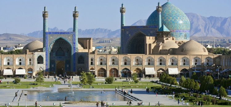
Meidan Emam, Esfahan
Built by Shah Abbas I the Great at the beginning of the 17th century, and bordered on all sides by monumental buildings linked by a series of two-storeyed arcades, the site is known for the Royal Mosque, the Mosque of Sheykh Lotfollah, the magnificent Portico of Qaysariyyeh and the 15th-century Timurid palace. They are an impressive testimony to the level of social and cultural life in Persia during the Safavid era.
Outstanding Universal Value
Brief Synthesis
The Meidan Emam is a public urban square in the centre of Esfahan, a city located on the main north-south and east-west routes crossing central Iran. It is one of the largest city squares in the world and an outstanding example of Iranian and Islamic architecture. Built by the Safavid shah Abbas I in the early 17th century, the square is bordered by two-storey arcades and anchored on each side by four magnificent buildings: to the east, the Sheikh Lotfallah Mosque; to the west, the pavilion of Ali Qapu; to the north, the portico of Qeyssariyeh; and to the south, the celebrated Royal Mosque. A homogenous urban ensemble built according to a unique, coherent, and harmonious plan, the Meidan Emam was the heart of the Safavid capital and is an exceptional urban realisation.
Also known as Naghsh-e Jahan (“Image of the World”), and formerly as Meidan-e Shah, Meidan Emam is not typical of urban ensembles in Iran, where cities are usually tightly laid out without sizeable open spaces. Esfahan’s public square, by contrast, is immense: 560 m long by 160 m wide, it covers almost 9 ha. All of the architectural elements that delineate the square, including its arcades of shops, are aesthetically remarkable, adorned with a profusion of enamelled ceramic tiles and paintings.
Of particular interest is the Royal Mosque (Masjed-e Shah), located on the south side of the square and angled to face Mecca. It remains the most celebrated example of the colourful architecture which reached its high point in Iran under the Safavid dynasty (1501-1722; 1729-1736). The pavilion of Ali Qapu on the west side forms the monumental entrance to the palatial zone and to the royal gardens which extend behind it. Its apartments, high portal, and covered terrace (tâlâr) are renowned. The portico of Qeyssariyeh on the north side leads to the 2-km-long Esfahan Bazaar, and the Sheikh Lotfallah Mosque on the east side, built as a private mosque for the royal court, is today considered one of the masterpieces of Safavid architecture.
The Meidan Emam was at the heart of the Safavid capital’s culture, economy, religion, social power, government, and politics. Its vast sandy esplanade was used for celebrations, promenades, and public executions, for playing polo and for assembling troops. The arcades on all sides of the square housed hundreds of shops; above the portico to the large Qeyssariyeh bazaar a balcony accommodated musicians giving public concerts; the tâlâr of Ali Qapu was connected from behind to the throne room, where the shah occasionally received ambassadors. In short, the royal square of Esfahan was the preeminent monument of Persian socio-cultural life during the Safavid dynasty.
Criterion (i): The Meidan Emam constitutes a homogenous urban ensemble, built over a short time span according to a unique, coherent, and harmonious plan. All the monuments facing the square are aesthetically remarkable. Of particular interest is the Royal Mosque, which is connected to the south side of the square by means of an immense, deep entrance portal with angled corners and topped with a half-dome, covered on its interior with enamelled faience mosaics. This portal, framed by two minarets, is extended to the south by a formal gateway hall (iwan) that leads at an angle to the courtyard, thereby connecting the mosque, which in keeping with tradition is oriented northeast/southwest (towards Mecca), to the square’s ensemble, which is oriented north/south. The Royal Mosque of Esfahan remains the most famous example of the colourful architecture which reached its high point in Iran under the Safavid dynasty. The pavilion of Ali Qapu forms the monumental entrance to the palatial zone and to the royal gardens which extend behind it. Its apartments, completely decorated with paintings and largely open to the outside, are renowned. On the square is its high portal (48 metres) flanked by several storeys of rooms and surmounted by a terrace (tâlâr) shaded by a practical roof resting on 18 thin wooden columns. All of the architectural elements of the Meidan Imam, including the arcades, are adorned with a profusion of enamelled ceramic tiles and with paintings, where floral ornamentation is dominant – flowering trees, vases, bouquets, etc. – without prejudice to the figurative compositions in the style of Riza-i Abbasi, who was head of the school of painting at Esfahan during the reign of Shah Abbas and was celebrated both inside and outside Persia.
Criterion (v): The royal square of Esfahan is an exceptional urban realisation in Iran, where cities are usually tightly laid out without open spaces, except for the courtyards of the caravanserais (roadside inns). This is an example of aform of urban architecture that is inherently vulnerable.
Criterion (vi): The Meidan Imam was the heart of the Safavid capital. Its vast sandy esplanade was used for promenades, for assembling troops, for playing polo, for celebrations, and for public executions. The arcades on all sides housed shops; above the portico to the large Qeyssariyeh bazaar a balcony accommodated musicians giving public concerts; the tâlâr of Ali Qapu was connected from behind to the throne room, where the shah occasionally received ambassadors. In short, the royal square of Esfahan was the preeminent monument of Persian socio-cultural life during the Safavid dynasty (1501-1722; 1729-1736).
Integrity
Within the boundaries of the property are located all the elements and components necessary to express the Outstanding Universal Value of the property, including, among others, the public urban square and the two-storey arcades that delineate it, the Sheikh Lotfallah Mosque, the pavilion of Ali Qapu, the portico of Qeyssariyeh, and the Royal Mosque.
Threats to the integrity of the property include economic development, which is giving rise to pressures to allow the construction of multi-storey commercial and parking buildings in the historic centre within the buffer zone; road widening schemes, which threaten the boundaries of the property; the increasing number of tourists; and fire.
Authenticity
The historical monuments at Meidan Emam, Esfahan, are authentic in terms of their forms and design, materials and substance, locations and setting, and spirit. The surface of the public urban square, once covered with sand, is now paved with stone. A pond was placed at the centre of the square, lawns were installed in the 1990s, and two entrances were added to the northeastern and western ranges of the square. These and future renovations, undertaken by Cultural Heritage experts, nonetheless employ domestic knowledge and technology in the direction of maintaining the authenticity of the property.
Management and Protection requirements
Meidan Emam, Esfahan, which is public property, was registered in the national list of Iranian monuments as item no. 102 on 5 January 1932, in accordance with the National Heritage Protection Law (1930, updated 1998) and theIranian Law on the Conservation of National Monuments (1982). Also registered individually are the Royal Mosque (Masjed-e Shah) (no. 107), Sheikh Lotfallah Mosque (no. 105), Ali Qapu pavilion (no. 104), and Qeyssariyeh portico (no. 103). The inscribed World Heritage property, which is owned by the Government of Iran, and its buffer zone are administered and supervised by the Iranian Cultural Heritage, Handicrafts and Tourism Organization (which is administered and funded by the Government of Iran), through its Esfahan office. The square enclosure belongs to the municipality; the bazaars around the square and the shops in the square’s environs are owned by the Endowments Office. There is a comprehensive municipal plan, but no Management Plan for the property. Financial resources (which are recognised as being inadequate) are provided through national, provincial, and municipal budgets and private individuals.
Sustaining the Outstanding Universal Value of the property over time will require developing, approving, and implementing a Management Plan for the property, in consultation with all stakeholders, that defines a strategic vision for the property and its buffer zone, considers infrastructure needs, and sets out a process to assess and control major development projects, with the objective of ensuring that the property does not suffer from adverse effects of development.
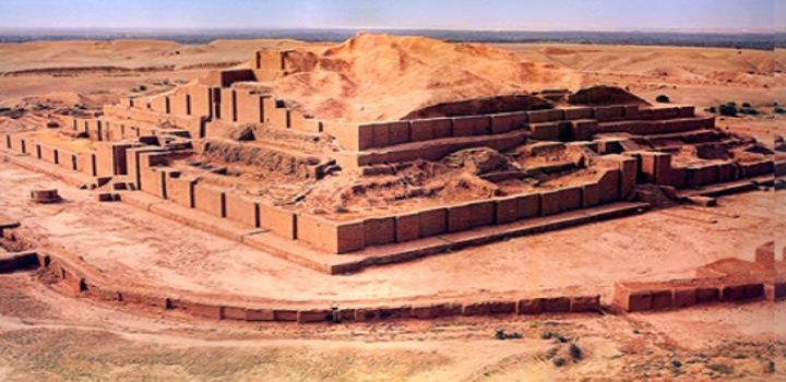
Tchogha Zanbil
The ruins of the holy city of the Kingdom of Elam, surrounded by three huge concentric walls, are found at Tchogha Zanbil. Founded c. 1250 B.C., the city remained unfinished after it was invaded by Ashurbanipal, as shown by the thousands of unused bricks left at the site.
Brief Synthesis
Located in ancient Elam (today Khuzestan province in southwest Iran), Tchogha Zanbil (Dur-Untash, or City of Untash, in Elamite) was founded by the Elamite king Untash-Napirisha (1275-1240 BCE) as the religious centre of Elam. The principal element of this complex is an enormous ziggurat dedicated to the Elamite divinities Inshushinak and Napirisha. It is the largest ziggurat outside of Mesopotamia and the best preserved of this type of stepped pyramidal monument. The archaeological site of Tchogha Zanbil is an exceptional expression of the culture, beliefs, and ritual traditions of one of the oldest indigenous peoples of Iran. Our knowledge of the architectural development of the middle Elamite period (1400-1100 BCE) comes from the ruins of Tchogha Zanbil and of the capital city of Susa 38 km to the north-west of the temple).
The archaeological site of Tchogha Zanbil covers a vast, arid plateau overlooking the rich valley of the river Ab-e Diz and its forests. A “sacred city” for the king’s residence, it was never completed and only a few priests lived there until it was destroyed by the Assyrian king Ashurbanipal about 640 BCE. The complex was protected by three concentric enclosure walls: an outer wall about 4 km in circumference enclosing a vast complex of residences and the royal quarter, where three monumental palaces have been unearthed (one is considered a tomb-palace that covers the remains of underground baked-brick structures containing the burials of the royal family); a second wall protecting the temples (Temenus); and the innermost wall enclosing the focal point of the ensemble, the ziggurat.
The ziggurat originally measured 105.2 m on each side and about 53 m in height, in five levels, and was crowned with a temple. Mud brick was the basic material of the whole ensemble. The ziggurat was given a facing of baked bricks, a number of which have cuneiform characters giving the names of deities in the Elamite and Akkadian languages. Though the ziggurat now stands only 24.75 m high, less than half its estimated original height, its state of preservation is unsurpassed. Studies of the ziggurat and the rest of the archaeological site of Tchogha Zanbil containing other temples, residences, tomb-palaces, and water reservoirs have made an important contribution to our knowledge about the architecture of this period of the Elamites, whose ancient culture persisted into the emerging Achaemenid (First Persian) Empire, which changed the face of the civilised world at that time.
Criterion (iii): The ruins of Susa and of Tchogha Zanbil are the sole testimonies to the architectural development of the middle Elamite period (1400-1100 BCE).
Criterion (iv): The ziggurat at Tchogha Zanbil remains to this day the best preserved monument of this type and the largest outside of Mesopotamia.
Integrity
Within the boundaries of the property are located all the elements and components necessary to express the Outstanding Universal Value of the property, including, among others, the concentric walls, the royal quarter, the temples, various dependencies, and the ziggurat. Almost none of the various architectural elements and spaces has been removed or suffered major damage. The integrity of the landscape and lifestyle of the indigenous communities has largely been protected due to being away from urban areas.
Identified threats to the integrity of the property include heavy rainfalls, which can have a damaging effect on exposed mud-brick structures; a change in the course of the river Ab-e Diz, which threatens the outer wall; sugar cane cultivation and processing, which have altered traditional land use and increased air and water pollution; and deforestation of the river valleys. Visitors were banned from climbing the ziggurat in 2002, and a lighting system has been installed and guards stationed at the site to protect it from illegal excavations.
Authenticity
The historical monuments of the archaeological site of Tchogha Zanbil are authentic in terms of their forms and design, materials and substance, and locations and setting. Several conservation measures have been undertaken since the original excavations of the site between 1946 and 1962, but they have not usually disturbed its historical authenticity.
Protection and management requirements
Tchogha Zanbil was registered in the national list of Iranian monuments as item no. 895 on 26 January 1970. Relevant national laws and regulations concerning the property include the National Heritage Protection Law (1930, updated 1998) and the 1980 Legal bill on preventing clandestine diggings and illegal excavations. The inscribed World Heritage property, which is owned by the Government of Iran, and its buffer zone are administered by the Iranian Cultural Heritage, Handicrafts and Tourism Organization (which is administered and funded by the Government of Iran). A Management Plan was prepared in 2003 and has since been implemented. Planning for tourism management, landscaping, and emergency evacuation for the property has been accomplished and implementation was in progress in 2013. A research centre has undertaken daily, monthly, and annual monitoring of the property since 1998. Financial resources for Tchogha Zanbil are provided through national budgets.
Conservation activities have been undertaken within a general framework, including development of scientific research programs; comprehensive conservation of the property and its natural-historical context; expansion of the conservation program to the surrounding environment; concentration on engaging the public and governmental organizations and agencies; and according special attention to programs for training and presentation (with the aim of developing cultural tourism) based on sustainable development. Objectives include research programs and promotion of a conservation management culture; scientific and comprehensive conservation of the property and surrounding area; and development of training and introductory programmes.
Sustaining the Outstanding Universal Value of the property over time will require creating a transparent and regular funding system, employing efficient and sustainable management systems, supporting continuous protection and presentation, enjoying the public support and giving life to the property, adopting a “minimum intervention” approach, and respecting the integrity and authenticity of the property and its surrounding environment. In addition, any outstanding recommendations of past expert missions to the property should be addressed.